Phimai geodata
Phimai (Nakhon Ratchasima) is a seat of a second-order administrative division; located in Thailand in Asia/Bangkok (GMT+7) time zone. With population of 13,084 people, there are 253 cities with bigger population in this country. Compared to other cities in Thailand, 53.2% of cities are located further ↓South; 72.9% of cities are located further ←West and 63.6% of cities have lower elevation than Phimai. Note1


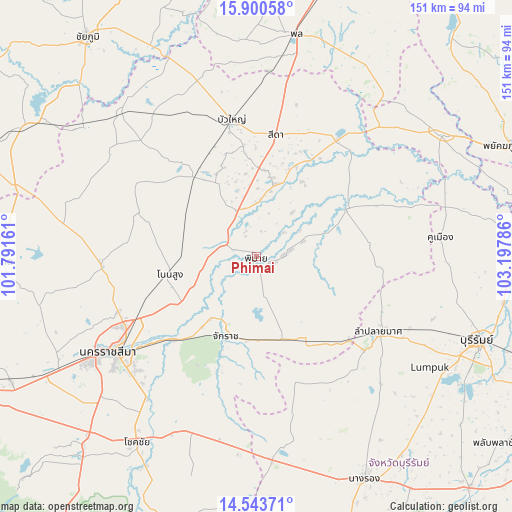
Phimai GPS coordinates[2]
15° 13' 23.664" North, 102° 29' 41.028" East
| Map corner | latitude | longitude |
|---|---|---|
| Upper-left | 15.90058°, | 101.79161° |
| Center: | 15.22324°, | 102.49473° |
| Lower-right: | 14.54371°, | 103.19786° |
| Map W x H: | 150.9×150.9 km | = 93.8×93.8mi |
| max Lat: | 20.43353° ⇑46.8% North |
| Phimai: | 15.22324° |
| min Lat: | ⇓53.2% South 5.77434° |
| min Long | Phimai | max Long |
| 97.93288° | 102.49473° | 105.49506° |
| W 72.9%⇐ | ⇒27.1% E |
Elevation
Elevation of Phimai is 157 m = 515 ft, and this is 31.5 m = 103 ft above average elevation for this country.
| Max E: |
1011 m = 3317 ft | 36.4% |
| Phimai | 157 m 515 ft | |
| Avg. | 125.5 m = 412 ft | |
Min E: |
1 m = 3 ft | 63.6% |
See also: Thailand elevation on elevation.city.
Geographical zone
Phimai is located in North Torrid zone (between Equator and Tropic of Cancer). Distance of this Northern Tropic circle is 913.3 km =567.5 mi to North.| Distance of | km | miles | from Phimai |
|---|---|---|---|
| North Pole | 8314.4 | 5166.3 | to North |
| Arctic Circle | 5708.5 | 3547.1 | to North |
| Tropic Cancer | 913.3 | 567.5 | to North |
| Equator | 1692.7 | 1051.8 | to South |


Nearby cities:
15 places around Phimai: (largest is in red/bold)
• Ban Huai Thalaeng
31.5 km =19.6 mi,  148°
148°
• Bua Yai
41 km =25.5 mi,  349°
349°
• Chakkarat
24.9 km =15.5 mi,  200°
200°
• Chaloem Phra Kiat
34.2 km =21.3 mi,  224°
224°
• Chum Phuang
29.9 km =18.6 mi,  62°
62°
• Huai Thalaeng
30 km =18.6 mi, 146°
• Kham Sakae Saeng
36.6 km =22.7 mi,  289°
289°
• Khong
30.3 km =18.8 mi,  324°
324°
• Lam Plai Mat
43 km =26.7 mi,  120°
120°
• Non Daeng
21.4 km =13.3 mi,  13°
13°
• Non Sung
26 km =16.2 mi,  259°
259°
• Non Thai
45.5 km =28.3 mi,  266°
266°
• Nong Hong
46.4 km =28.8 mi, 154°
• Prathai
42.3 km =26.3 mi,  35°
35°
• Sida
37.1 km =23.1 mi, 11°
Sources, notices
• [Note1] Compared only with cities in Thailand existing in our database
• [Src1] Map data: © OpenStreetMap contributors (CC-BY-SA)
• [Src2] Other city data from geonames.org with taken over terms of usage.
• [Src3] Geographical zone / Annual Mean Temperature by Robert A. Rohde @ Wikipedia
