Kham Sakae Saeng geodata
Kham Sakae Saeng (Nakhon Ratchasima) is a seat of a second-order administrative division; located in Thailand in Asia/Bangkok (GMT+7) time zone. With population of 11,018 people, there are 277 cities with bigger population in this country. Compared to other cities in Thailand, 55.7% of cities are located further ↓South; 68.7% of cities are located further ←West and 77.3% of cities have lower elevation than Kham Sakae Saeng. Note1


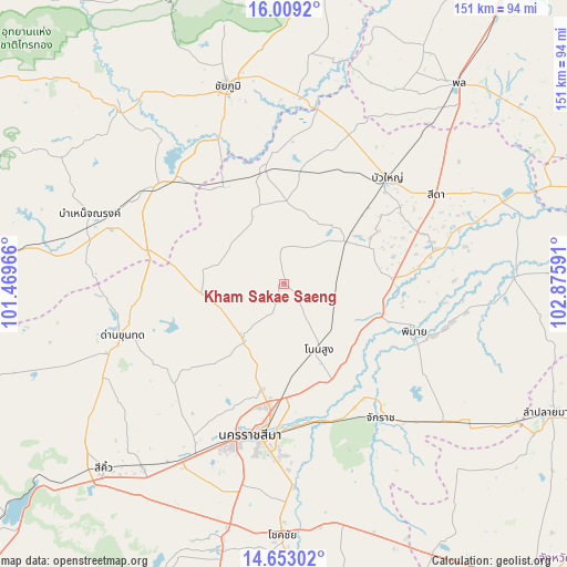
Kham Sakae Saeng GPS coordinates[2]
15° 19' 55.956" North, 102° 10' 22.008" East
| Map corner | latitude | longitude |
|---|---|---|
| Upper-left | 16.0092°, | 101.46966° |
| Center: | 15.33221°, | 102.17278° |
| Lower-right: | 14.65302°, | 102.87591° |
| Map W x H: | 150.8×150.8 km | = 93.7×93.7mi |
| max Lat: | 20.43353° ⇑44.3% North |
| Kham Sakae Saeng: | 15.33221° |
| min Lat: | ⇓55.7% South 5.77434° |
| min Long | Kham Sakae Saen | max Long |
| 97.93288° | 102.17278° | 105.49506° |
| W 68.7%⇐ | ⇒31.3% E |
Elevation
Elevation of Kham Sakae Saeng is 189 m = 620 ft, and this is 63.5 m = 208 ft above average elevation for this country.
| Max E: |
1011 m = 3317 ft | 22.7% |
| Kham Sakae Saeng | 189 m 620 ft | |
| Avg. | 125.5 m = 412 ft | |
Min E: |
1 m = 3 ft | 77.3% |
See also: Thailand elevation on elevation.city.
Geographical zone
Kham Sakae Saeng is located in North Torrid zone (between Equator and Tropic of Cancer). Distance of this Northern Tropic circle is 901.1 km =559.9 mi to North.| Distance of | km | miles | from Kham Sakae Saeng |
|---|---|---|---|
| North Pole | 8302.3 | 5158.8 | to North |
| Arctic Circle | 5696.4 | 3539.6 | to North |
| Tropic Cancer | 901.1 | 559.9 | to North |
| Equator | 1704.8 | 1059.3 | to South |


Nearby cities:
15 places around Kham Sakae Saeng: (largest is in red/bold)
• Ban Lueam
31.1 km =19.3 mi,  351°
351°
• Bua Yai
39.1 km =24.3 mi,  43°
43°
• Chakkarat
43.8 km =27.2 mi,  143°
143°
• Chaloem Phra Kiat
37.8 km =23.5 mi,  163°
163°
• Chatturat
43.6 km =27.1 mi,  306°
306°
• Dan Khun Thot
45.2 km =28.1 mi,  252°
252°
• Kaeng Sanam Nang
47.2 km =29.3 mi,  10°
10°
• Khong
20.8 km =12.9 mi,  53°
53°
• Nakhon Ratchasima
40.9 km =25.4 mi,  190°
190°
• Noen Sa-nga
31.7 km =19.7 mi,  324°
324°
• Non Daeng
40.4 km =25.1 mi,  77°
77°
• Non Sung
19.2 km =11.9 mi,  151°
151°
• Non Thai
18.7 km =11.6 mi,  215°
215°
• Phimai
36.6 km =22.7 mi,  109°
109°
• Phra Thong Kham
17.9 km =11.1 mi, 246°
Sources, notices
• [Note1] Compared only with cities in Thailand existing in our database
• [Src1] Map data: © OpenStreetMap contributors (CC-BY-SA)
• [Src2] Other city data from geonames.org with taken over terms of usage.
• [Src3] Geographical zone / Annual Mean Temperature by Robert A. Rohde @ Wikipedia
