Pom Prap Sattru Phai geodata
Pom Prap Sattru Phai (Bangkok) is a seat of a second-order administrative division; located in Thailand in Asia/Bangkok (GMT+7) time zone. In our database, there are 331 cities with bigger population. Compared to other cities in Thailand, 69.8% of cities are located further ↑North; 57.6% of cities are located further →East and 76.7% of cities have higher elevation than Pom Prap Sattru Phai. Note1


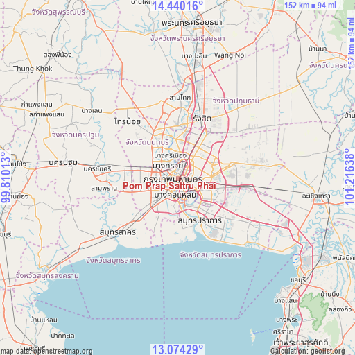
Pom Prap Sattru Phai GPS coordinates[2]
13° 45' 29.592" North, 100° 30' 47.7" East
| Map corner | latitude | longitude |
|---|---|---|
| Upper-left | 14.44016°, | 99.81013° |
| Center: | 13.75822°, | 100.51325° |
| Lower-right: | 13.07429°, | 101.21638° |
| Map W x H: | 151.9×151.9 km | = 94.4×94.4mi |
| max Lat: | 20.43353° ⇑69.8% North |
| Pom Prap Sattru Phai: | 13.75822° |
| min Lat: | ⇓30.2% South 5.77434° |
| min Long | Pom Prap Sattru | max Long |
| 97.93288° | 100.51325° | 105.49506° |
| W 42.4%⇐ | ⇒57.6% E |
Elevation
Elevation of Pom Prap Sattru Phai is 14 m = 46 ft, and this is 111.5 m = 366 ft below average elevation for this country.
| Max E: |
1011 m = 3317 ft | 76.7% |
| Avg. | 125.5 m = 412 ft | |
| Pom Prap Sattru Phai | 14 m = 46 ft | |
Min E: |
1 m = 3 ft | 23.3% |
See also: Thailand elevation on elevation.city.
Geographical zone
Pom Prap Sattru Phai is located in North Torrid zone (between Equator and Tropic of Cancer). Distance of this Northern Tropic circle is 1076.1 km =668.7 mi to North.| Distance of | km | miles | from Pom Prap Sattru Phai |
|---|---|---|---|
| North Pole | 8477.3 | 5267.5 | to North |
| Arctic Circle | 5871.4 | 3648.3 | to North |
| Tropic Cancer | 1076.1 | 668.7 | to North |
| Equator | 1529.8 | 950.6 | to South |


Nearby cities:
15 places around Pom Prap Sattru Phai: (largest is in red/bold)
• Bang Rak
3.3 km =2.1 mi,  159°
159°
• Bang Sue
6.3 km =3.9 mi,  24°
24°
• Bangkok
1.4 km =0.9 mi,  249°
249°
• Bangkok Noi
3.8 km =2.4 mi,  277°
277°
• Bangkok Yai
5.6 km =3.5 mi,  225°
225°
• Din Daeng
4.5 km =2.8 mi,  73°
73°
• Dusit
2.3 km =1.4 mi, 18°
• Khlong San
3.1 km =1.9 mi,  188°
188°
• Pathum Wan
2.7 km =1.7 mi,  154°
154°
• Phaya Thai
4 km =2.5 mi,  52°
52°
• Phra Nakhon
1.8 km =1.1 mi,  295°
295°
• Ratchathewi
2.2 km =1.4 mi,  87°
87°
• Samphanthawong
3 km =1.9 mi,  178°
178°
• Sathon
5.7 km =3.5 mi,  165°
165°
• Thon Buri
4.8 km =3 mi,  219°
219°
Sources, notices
• [Note1] Compared only with cities in Thailand existing in our database
• [Src1] Map data: © OpenStreetMap contributors (CC-BY-SA)
• [Src2] Other city data from geonames.org with taken over terms of usage.
• [Src3] Geographical zone / Annual Mean Temperature by Robert A. Rohde @ Wikipedia
