Bang Sue geodata
Bang Sue (Bangkok) is a seat of a second-order administrative division; located in Thailand in Asia/Bangkok (GMT+7) time zone. In our database, there are 331 cities with bigger population. Compared to other cities in Thailand, 67.8% of cities are located further ↑North; 56.2% of cities are located further →East and 85.9% of cities have higher elevation than Bang Sue. Note1


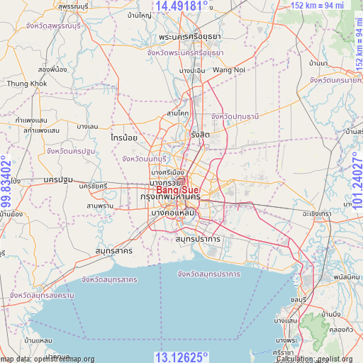
Bang Sue GPS coordinates[2]
13° 48' 36.108" North, 100° 32' 13.704" East
| Map corner | latitude | longitude |
|---|---|---|
| Upper-left | 14.49181°, | 99.83402° |
| Center: | 13.81003°, | 100.53714° |
| Lower-right: | 13.12625°, | 101.24027° |
| Map W x H: | 151.8×151.8 km | = 94.3×94.3mi |
| max Lat: | 20.43353° ⇑67.8% North |
| Bang Sue: | 13.81003° |
| min Lat: | ⇓32.2% South 5.77434° |
| min Long | Bang Sue | max Long |
| 97.93288° | 100.53714° | 105.49506° |
| W 43.8%⇐ | ⇒56.2% E |
Elevation
Elevation of Bang Sue is 10 m = 33 ft, and this is 115.5 m = 379 ft below average elevation for this country.
| Max E: |
1011 m = 3317 ft | 85.9% |
| Avg. | 125.5 m = 412 ft | |
| Bang Sue | 10 m = 33 ft | |
Min E: |
1 m = 3 ft | 14.1% |
See also: Thailand elevation on elevation.city.
Geographical zone
Bang Sue is located in North Torrid zone (between Equator and Tropic of Cancer). Distance of this Northern Tropic circle is 1070.4 km =665.1 mi to North.| Distance of | km | miles | from Bang Sue |
|---|---|---|---|
| North Pole | 8471.5 | 5263.9 | to North |
| Arctic Circle | 5865.6 | 3644.7 | to North |
| Tropic Cancer | 1070.4 | 665.1 | to North |
| Equator | 1535.5 | 954.1 | to South |


Nearby cities:
15 places around Bang Sue: (largest is in red/bold)
• Bang Kruai
7 km =4.3 mi,  265°
265°
• Bangkok
7.3 km =4.5 mi,  211°
211°
• Bangkok Noi
8.3 km =5.2 mi,  230°
230°
• Chatuchak
3.2 km =2 mi,  49°
49°
• Din Daeng
4.8 km =3 mi,  158°
158°
• Dusit
4.1 km =2.5 mi, 207°
• Huai Khwang
5.8 km =3.6 mi,  129°
129°
• Lat Phrao
7.6 km =4.7 mi,  95°
95°
• Mueang Nonthaburi
6.1 km =3.8 mi,  336°
336°
• Pathum Wan
8.3 km =5.2 mi,  189°
189°
• Phaya Thai
3.4 km =2.1 mi,  169°
169°
• Phra Nakhon
6.5 km =4 mi,  219°
219°
• Pom Prap Sattru Phai
6.3 km =3.9 mi,  204°
204°
• Ratchathewi
5.7 km =3.5 mi,  183°
183°
• Wang Thonglang
8.5 km =5.3 mi,  108°
108°
Sources, notices
• [Note1] Compared only with cities in Thailand existing in our database
• [Src1] Map data: © OpenStreetMap contributors (CC-BY-SA)
• [Src2] Other city data from geonames.org with taken over terms of usage.
• [Src3] Geographical zone / Annual Mean Temperature by Robert A. Rohde @ Wikipedia
