In Buri geodata
In Buri (Sing Buri) is a seat of a second-order administrative division; located in Thailand in Asia/Bangkok (GMT+7) time zone. In our database, there are 331 cities with bigger population. Compared to other cities in Thailand, 50.4% of cities are located further ↓South; 63.6% of cities are located further →East and 72.3% of cities have higher elevation than In Buri. Note1


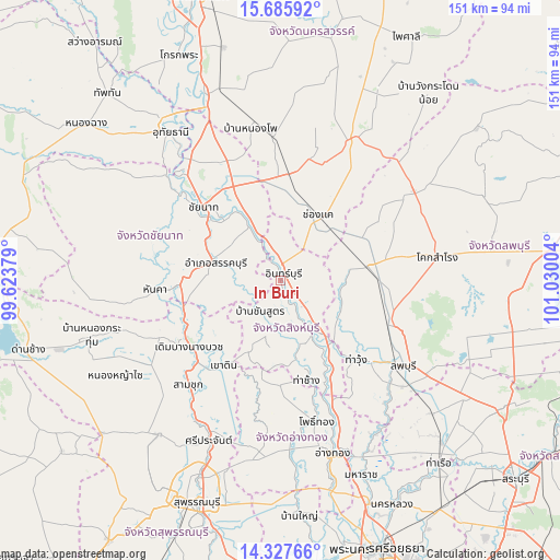
In Buri GPS coordinates[2]
15° 0' 28.332" North, 100° 19' 36.876" East
| Map corner | latitude | longitude |
|---|---|---|
| Upper-left | 15.68592°, | 99.62379° |
| Center: | 15.00787°, | 100.32691° |
| Lower-right: | 14.32766°, | 101.03004° |
| Map W x H: | 151×151 km | = 93.8×93.8mi |
| max Lat: | 20.43353° ⇑49.6% North |
| In Buri: | 15.00787° |
| min Lat: | ⇓50.4% South 5.77434° |
| min Long | In Buri | max Long |
| 97.93288° | 100.32691° | 105.49506° |
| W 36.4%⇐ | ⇒63.6% E |
Elevation
Elevation of In Buri is 19 m = 62 ft, and this is 106.5 m = 349 ft below average elevation for this country.
| Max E: |
1011 m = 3317 ft | 72.3% |
| Avg. | 125.5 m = 412 ft | |
| In Buri | 19 m = 62 ft | |
Min E: |
1 m = 3 ft | 27.7% |
See also: Thailand elevation on elevation.city.
Geographical zone
In Buri is located in North Torrid zone (between Equator and Tropic of Cancer). Distance of this Northern Tropic circle is 937.2 km =582.3 mi to North.| Distance of | km | miles | from In Buri |
|---|---|---|---|
| North Pole | 8338.3 | 5181.2 | to North |
| Arctic Circle | 5732.5 | 3562 | to North |
| Tropic Cancer | 937.2 | 582.3 | to North |
| Equator | 1668.7 | 1036.9 | to South |


Nearby cities:
15 places around In Buri: (largest is in red/bold)
• Ban Mi
22.9 km =14.2 mi,  79°
79°
• Bang Racham
12.9 km =8 mi,  184°
184°
• Bang Rachan
23.5 km =14.6 mi,  185°
185°
• Chai Nat
29.5 km =18.3 mi,  312°
312°
• Doem Bang Nang Buat
30 km =18.6 mi,  235°
235°
• Doembang Nangbuat
31.2 km =19.4 mi,  231°
231°
• Phrom Buri
27.7 km =17.2 mi,  150°
150°
• Sankhaburi
18.3 km =11.4 mi,  283°
283°
• Sapphaya
17.9 km =11.1 mi,  329°
329°
• Sawaeng Ha
29.1 km =18.1 mi, 179°
• Sawaengha
28.5 km =17.7 mi, 180°
• Sing Buri
15.7 km =9.8 mi, 147°
• Takhli
28.5 km =17.7 mi,  3°
3°
• Tha Chang
28.2 km =17.5 mi,  166°
166°
• Tha Wung
29 km =18 mi,  139°
139°
Sources, notices
• [Note1] Compared only with cities in Thailand existing in our database
• [Src1] Map data: © OpenStreetMap contributors (CC-BY-SA)
• [Src2] Other city data from geonames.org with taken over terms of usage.
• [Src3] Geographical zone / Annual Mean Temperature by Robert A. Rohde @ Wikipedia
