Tartiki geodata
Tartiki (Khatlon) is a populated place; located in Tajikistan in Asia/Dushanbe (GMT+5) time zone. With population of 2,342 people, there are 60 cities with bigger population in this country. Compared to other cities in Tajikistan, 85.2% of cities are located further ↑North; 96.6% of cities are located further →East and 70.5% of cities have higher elevation than Tartiki. Note1


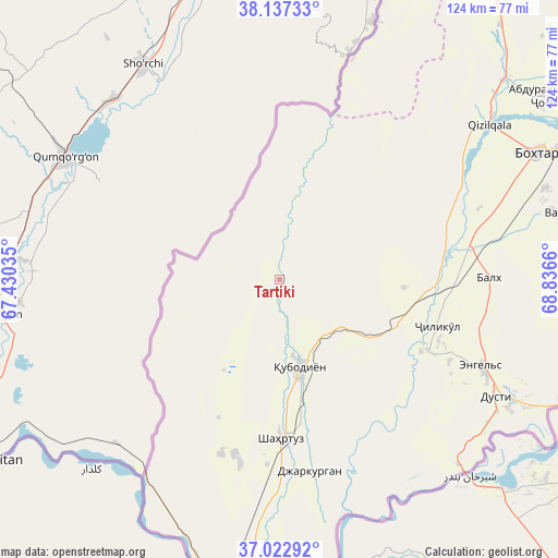
Tartiki GPS coordinates[2]
37° 34' 55.956" North, 68° 8' 0.492" East
| Map corner | latitude | longitude |
|---|---|---|
| Upper-left | 38.13733°, | 67.43035° |
| Center: | 37.58221°, | 68.13347° |
| Lower-right: | 37.02292°, | 68.8366° |
| Map W x H: | 123.9×123.9 km | = 77×77mi |
| max Lat: | 40.99827° ⇑85.2% North |
| Tartiki: | 37.58221° |
| min Lat: | ⇓14.8% South 36.72484° |
| min Long | Tartiki | max Long |
| 67.60931° | 68.13347° | 73.96674° |
| W 3.4%⇐ | ⇒96.6% E |
Elevation
Elevation of Tartiki is 436 m = 1430 ft, and this is 526.5 m = 1727 ft below average elevation for this country.
| Max E: |
3607 m = 11834 ft | 70.5% |
| Avg. | 962.5 m = 3158 ft | |
| Tartiki | 436 m = 1430 ft | |
Min E: |
324 m = 1063 ft | 29.5% |
See also: Tajikistan elevation on elevation.city.
Geographical zone
Tartiki is located in North temperate zone (between Tropic of Cancer and the Arctic Circle). Distance of this Northern Tropic circle is 1572.8 km =977.3 mi to South.| Distance of | km | miles | from Tartiki |
|---|---|---|---|
| North Pole | 5828.3 | 3621.5 | to North |
| Arctic Circle | 3222.4 | 2002.3 | to North |
| Tropic Cancer | 1572.8 | 977.3 | to South |
| Equator | 4178.8 | 2596.6 | to South |


Nearby cities:
15 places around Tartiki: (largest is in red/bold)
• Bahorí
23.5 km =14.6 mi,  211°
211°
• Boshchorbogh
6.9 km =4.3 mi,  183°
183°
• Bŭstonqal’a
68.1 km =42.3 mi,  64°
64°
• Dŭstí
53.6 km =33.3 mi,  119°
119°
• Gharavŭtí
27.7 km =17.2 mi,  93°
93°
• Ismoili Somoní
62.2 km =38.6 mi,  70°
70°
• Jilikŭl
36.5 km =22.7 mi,  106°
106°
• Kirov
69.1 km =42.9 mi, 67°
• Kolkhozobod
46.3 km =28.8 mi, 89°
• Moskovskiy
39.5 km =24.5 mi, 85°
• Orzu
60.5 km =37.6 mi, 92°
• Qubodiyon
19.7 km =12.2 mi,  166°
166°
• Qŭrghonteppa
63.5 km =39.5 mi, 63°
• Shahritus
35.6 km =22.1 mi, 179°
• Vakhsh
63.5 km =39.5 mi,  76°
76°
Sources, notices
• [Note1] Compared only with cities in Tajikistan existing in our database
• [Src1] Map data: © OpenStreetMap contributors (CC-BY-SA)
• [Src2] Other city data from geonames.org with taken over terms of usage.
• [Src3] Geographical zone / Annual Mean Temperature by Robert A. Rohde @ Wikipedia
