Kirov geodata
Kirov (Khatlon) is a populated place; located in Tajikistan in Asia/Dushanbe (GMT+5) time zone. With population of 7,696 people, there are 43 cities with bigger population in this country. Compared to other cities in Tajikistan, 76.1% of cities are located further ↑North; 65.9% of cities are located further →East and 67% of cities have higher elevation than Kirov. Note1


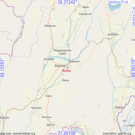
Kirov GPS coordinates[2]
37° 49' 8.688" North, 68° 51' 32.58" East
| Map corner | latitude | longitude |
|---|---|---|
| Upper-left | 38.37242°, | 68.15593° |
| Center: | 37.81908°, | 68.85905° |
| Lower-right: | 37.26156°, | 69.56218° |
| Map W x H: | 123.5×123.5 km | = 76.7×76.7mi |
| max Lat: | 40.99827° ⇑76.1% North |
| Kirov: | 37.81908° |
| min Lat: | ⇓23.9% South 36.72484° |
| min Long | Kirov | max Long |
| 67.60931° | 68.85905° | 73.96674° |
| W 34.1%⇐ | ⇒65.9% E |
Elevation
Elevation of Kirov is 445 m = 1460 ft, and this is 517.5 m = 1698 ft below average elevation for this country.
| Max E: |
3607 m = 11834 ft | 67% |
| Avg. | 962.5 m = 3158 ft | |
| Kirov | 445 m = 1460 ft | |
Min E: |
324 m = 1063 ft | 33% |
See also: Tajikistan elevation on elevation.city.
Geographical zone
Kirov is located in North temperate zone (between Tropic of Cancer and the Arctic Circle). Distance of this Northern Tropic circle is 1599.2 km =993.7 mi to South.| Distance of | km | miles | from Kirov |
|---|---|---|---|
| North Pole | 5802 | 3605.2 | to North |
| Arctic Circle | 3196.1 | 1986 | to North |
| Tropic Cancer | 1599.2 | 993.7 | to South |
| Equator | 4205.1 | 2612.9 | to South |


Nearby cities:
15 places around Kirov: (largest is in red/bold)
• Abdurahmoni Jomí
14.8 km =9.2 mi,  342°
342°
• Bŭstonqal’a
4 km =2.5 mi,  322°
322°
• Danghara
52.2 km =32.4 mi,  53°
53°
• Dŭstí
55.1 km =34.2 mi,  198°
198°
• Gharavŭtí
45.8 km =28.5 mi,  232°
232°
• Ismoili Somoní
7.8 km =4.8 mi,  220°
220°
• Jilikŭl
46.5 km =28.9 mi, 218°
• Kolkhozobod
31.1 km =19.3 mi,  214°
214°
• Moskovskiy
33.8 km =21 mi, 226°
• Obikiik
41.5 km =25.8 mi, 335°
• Orzu
29.2 km =18.1 mi,  186°
186°
• Qŭrghonteppa
7 km =4.3 mi,  283°
283°
• Sarband
8 km =5 mi,  43°
43°
• Vakhsh
11.8 km =7.3 mi, 190°
• Yovon
57.2 km =35.5 mi,  15°
15°
Sources, notices
• [Note1] Compared only with cities in Tajikistan existing in our database
• [Src1] Map data: © OpenStreetMap contributors (CC-BY-SA)
• [Src2] Other city data from geonames.org with taken over terms of usage.
• [Src3] Geographical zone / Annual Mean Temperature by Robert A. Rohde @ Wikipedia
