Balkanabat geodata
Balkanabat (Balkan) is a seat of a first-order administrative division; located in Turkmenistan in Asia/Ashgabat (GMT+5) time zone. With population of 87,822 people, there are 4 cities with bigger population in this country. Compared to other cities in Turkmenistan, 73.3% of cities are located further ↓South; 96.7% of cities are located further →East and 93.3% of cities have higher elevation than Balkanabat. Note1


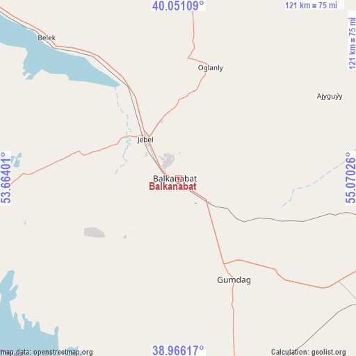
Balkanabat GPS coordinates[2]
39° 30' 38.7" North, 54° 22' 1.668" East
| Map corner | latitude | longitude |
|---|---|---|
| Upper-left | 40.05109°, | 53.66401° |
| Center: | 39.51075°, | 54.36713° |
| Lower-right: | 38.96617°, | 55.07026° |
| Map W x H: | 120.6×120.6 km | = 74.9×74.9mi |
| max Lat: | 42.32773° ⇑26.7% North |
| Balkanabat: | 39.51075° |
| min Lat: | ⇓73.3% South 35.27992° |
| min Long | Balkanabat | max Long |
| 52.95517° | 54.36713° | 66.04656° |
| W 3.3%⇐ | ⇒96.7% E |
Elevation
Elevation of Balkanabat is 11 m = 36 ft, and this is 185.4 m = 608 ft below average elevation for this country.
| Max E: |
649 m = 2129 ft | 93.3% |
| Avg. | 196.4 m = 644 ft | |
| Balkanabat | 11 m = 36 ft | |
Min E: |
5 m = 16 ft | 6.7% |
See also: Balkanabat elevation on elevation.city.
Geographical zone
Balkanabat is located in North temperate zone (between Tropic of Cancer and the Arctic Circle). Distance of this Northern Tropic circle is 1787.3 km =1110.6 mi to South.| Distance of | km | miles | from Balkanabat |
|---|---|---|---|
| North Pole | 5613.9 | 3488.3 | to North |
| Arctic Circle | 3008 | 1869.1 | to North |
| Tropic Cancer | 1787.3 | 1110.6 | to South |
| Equator | 4393.2 | 2729.8 | to South |


Nearby cities:
6 places around Balkanabat: (largest is in red/bold)
• Baharly
290.6 km =180.6 mi,  114°
114°
• Bereket
103 km =64 mi, 106°
• Gumdag
38.9 km =24.2 mi,  150°
150°
• Magtymguly
204 km =126.8 mi,  125°
125°
• Serdar
174.8 km =108.6 mi, 109°
• Türkmenbaşy
133.4 km =82.9 mi,  295°
295°
Sources, notices
• [Note1] Compared only with cities in Turkmenistan existing in our database
• [Src1] Map data: © OpenStreetMap contributors (CC-BY-SA)
• [Src2] Other city data from geonames.org with taken over terms of usage.
• [Src3] Geographical zone / Annual Mean Temperature by Robert A. Rohde @ Wikipedia
