Baharly geodata
Baharly (Ahal) is a populated place; located in Turkmenistan in Asia/Ashgabat (GMT+5) time zone. With population of 22,991 people, there are 16 cities with bigger population in this country. Compared to other cities in Turkmenistan, 56.7% of cities are located further ↑North; 80% of cities are located further →East and 60% of cities have higher elevation than Baharly. Note1


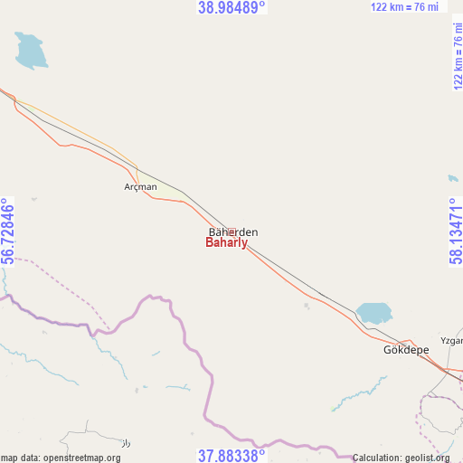
Baharly GPS coordinates[2]
38° 26' 10.464" North, 57° 25' 53.688" East
| Map corner | latitude | longitude |
|---|---|---|
| Upper-left | 38.98489°, | 56.72846° |
| Center: | 38.43624°, | 57.43158° |
| Lower-right: | 37.88338°, | 58.13471° |
| Map W x H: | 122.5×122.5 km | = 76.1×76.1mi |
| max Lat: | 42.32773° ⇑56.7% North |
| Baharly: | 38.43624° |
| min Lat: | ⇓43.3% South 35.27992° |
| min Long | Baharly | max Long |
| 52.95517° | 57.43158° | 66.04656° |
| W 20%⇐ | ⇒80% E |
Elevation
Elevation of Baharly is 160 m = 525 ft, and this is 36.4 m = 119 ft below average elevation for this country.
| Max E: |
649 m = 2129 ft | 60% |
| Avg. | 196.4 m = 644 ft | |
| Baharly | 160 m = 525 ft | |
Min E: |
5 m = 16 ft | 40% |
See also: Turkmenistan elevation on elevation.city.
Geographical zone
Baharly is located in North temperate zone (between Tropic of Cancer and the Arctic Circle). Distance of this Northern Tropic circle is 1667.8 km =1036.3 mi to South.| Distance of | km | miles | from Baharly |
|---|---|---|---|
| North Pole | 5733.4 | 3562.6 | to North |
| Arctic Circle | 3127.5 | 1943.3 | to North |
| Tropic Cancer | 1667.8 | 1036.3 | to South |
| Equator | 4273.7 | 2655.6 | to South |


Nearby cities:
11 places around Baharly: (largest is in red/bold)
• Abadan
79.2 km =49.2 mi,  122°
122°
• Annau
112.7 km =70 mi, 122°
• Arçabil
81.7 km =50.8 mi,  135°
135°
• Ashgabat
99.2 km =61.6 mi, 123°
• Balkanabat
290.6 km =180.6 mi,  294°
294°
• Bereket
188.7 km =117.3 mi,  298°
298°
• Gumdag
260.6 km =161.9 mi, 289°
• Kaka
226.5 km =140.7 mi, 122°
• Magtymguly
100.2 km =62.3 mi,  270°
270°
• Serdar
116.9 km =72.6 mi, 300°
• Tejen
294 km =182.7 mi,  113°
113°
Sources, notices
• [Note1] Compared only with cities in Turkmenistan existing in our database
• [Src1] Map data: © OpenStreetMap contributors (CC-BY-SA)
• [Src2] Other city data from geonames.org with taken over terms of usage.
• [Src3] Geographical zone / Annual Mean Temperature by Robert A. Rohde @ Wikipedia
