Tagta geodata
Tagta (Daşoguz) is a populated place; located in Turkmenistan in Asia/Ashgabat (GMT+5) time zone. With population of 16,635 people, there are 23 cities with bigger population in this country. Compared to other cities in Turkmenistan, 83.3% of cities are located further ↓South; 53.3% of cities are located further ←West and 73.3% of cities have higher elevation than Tagta. Note1


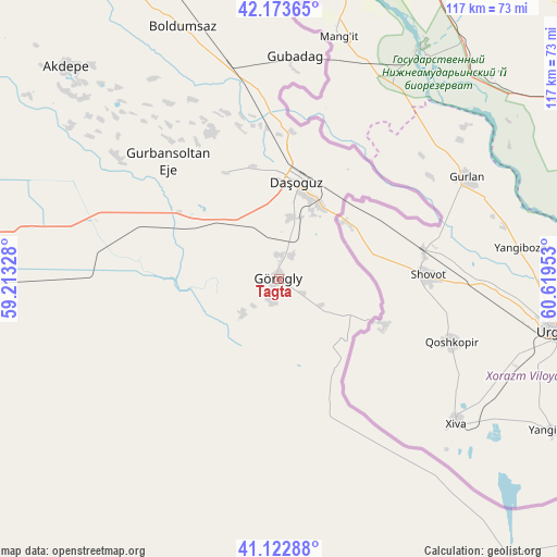
Tagta GPS coordinates[2]
41° 39' 1.476" North, 59° 54' 59.04" East
| Map corner | latitude | longitude |
|---|---|---|
| Upper-left | 42.17365°, | 59.21328° |
| Center: | 41.65041°, | 59.9164° |
| Lower-right: | 41.12288°, | 60.61953° |
| Map W x H: | 116.8×116.8 km | = 72.6×72.6mi |
| max Lat: | 42.32773° ⇑16.7% North |
| Tagta: | 41.65041° |
| min Lat: | ⇓83.3% South 35.27992° |
| min Long | Tagta | max Long |
| 52.95517° | 59.9164° | 66.04656° |
| W 53.3%⇐ | ⇒46.7% E |
Elevation
Elevation of Tagta is 86 m = 282 ft, and this is 110.4 m = 362 ft below average elevation for this country.
| Max E: |
649 m = 2129 ft | 73.3% |
| Avg. | 196.4 m = 644 ft | |
| Tagta | 86 m = 282 ft | |
Min E: |
5 m = 16 ft | 26.7% |
See also: Turkmenistan elevation on elevation.city.
Geographical zone
Tagta is located in North temperate zone (between Tropic of Cancer and the Arctic Circle). Distance of this Northern Tropic circle is 2025.2 km =1258.4 mi to South.| Distance of | km | miles | from Tagta |
|---|---|---|---|
| North Pole | 5376 | 3340.5 | to North |
| Arctic Circle | 2770.1 | 1721.3 | to North |
| Tropic Cancer | 2025.2 | 1258.4 | to South |
| Equator | 4631.1 | 2877.6 | to South |


Nearby cities:
8 places around Tagta: (largest is in red/bold)
• Abadan
425.9 km =264.6 mi,  200°
200°
• Akdepe
63.3 km =39.3 mi,  315°
315°
• Boldumsaz
56.9 km =35.4 mi,  339°
339°
• Daşoguz
21.1 km =13.1 mi,  11°
11°
• Gazojak
134.3 km =83.5 mi,  112°
112°
• Köneürgench
98.2 km =61 mi, 320°
• Seydi
349.6 km =217.2 mi,  133°
133°
• Yylanly
30 km =18.6 mi,  312°
312°
Sources, notices
• [Note1] Compared only with cities in Turkmenistan existing in our database
• [Src1] Map data: © OpenStreetMap contributors (CC-BY-SA)
• [Src2] Other city data from geonames.org with taken over terms of usage.
• [Src3] Geographical zone / Annual Mean Temperature by Robert A. Rohde @ Wikipedia
