Yıldız geodata
Yıldız (Şanlıurfa) is a populated place; located in Turkey in Europe/Istanbul (GMT+3) time zone. With population of 542 people, there are 1284 cities with bigger population in this country. Compared to other cities in Turkey, 89.8% of cities are located further ↑North; 63.7% of cities are located further ←West and 61.4% of cities have higher elevation than Yıldız. Note1


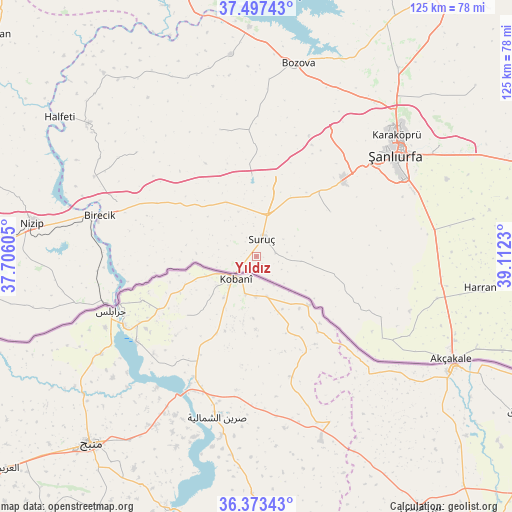
Yıldız GPS coordinates[2]
36° 56' 15" North, 38° 24' 33.012" East
| Map corner | latitude | longitude |
|---|---|---|
| Upper-left | 37.49743°, | 37.70605° |
| Center: | 36.9375°, | 38.40917° |
| Lower-right: | 36.37343°, | 39.1123° |
| Map W x H: | 125×125 km | = 77.7×77.7mi |
| max Lat: | 42.02683° ⇑89.8% North |
| Yıldız: | 36.9375° |
| min Lat: | ⇓10.2% South 35.9025° |
| min Long | Yıldız | max Long |
| 25.90902° | 38.40917° | 44.60099° |
| W 63.7%⇐ | ⇒36.3% E |
Elevation
Elevation of Yıldız is 487 m = 1598 ft, and this is 230.4 m = 756 ft below average elevation for this country.
| Max E: |
2682 m = 8799 ft | 61.4% |
| Avg. | 717.4 m = 2354 ft | |
| Yıldız | 487 m = 1598 ft | |
Min E: |
0 m = 0 ft | 38.6% |
See also: Turkey elevation on elevation.city.
Geographical zone
Yıldız is located in North temperate zone (between Tropic of Cancer and the Arctic Circle). Distance of this Northern Tropic circle is 1501.1 km =932.7 mi to South.| Distance of | km | miles | from Yıldız |
|---|---|---|---|
| North Pole | 5900 | 3666.1 | to North |
| Arctic Circle | 3294.1 | 2046.9 | to North |
| Tropic Cancer | 1501.1 | 932.7 | to South |
| Equator | 4107.1 | 2552 | to South |


Nearby cities:
15 places around Yıldız: (largest is in red/bold)
• Arslanlı
27.9 km =17.3 mi,  281°
281°
• Aşağı Oylum
14.6 km =9.1 mi,  124°
124°
• Binatlı
2.4 km =1.5 mi,  260°
260°
• Boybeyi
27.3 km =17 mi,  99°
99°
• Kanlıavşar
32.3 km =20.1 mi,  344°
344°
• Küçük Ziyaret
4.7 km =2.9 mi,  82°
82°
• Küçükkendirci
6.6 km =4.1 mi,  237°
237°
• Mağaralı
29.9 km =18.6 mi, 276°
• Mürşitpınar
6.7 km =4.2 mi, 235°
• Payamlı
21.2 km =13.2 mi,  58°
58°
• Suruç
4.5 km =2.8 mi,  18°
18°
• Uysallı
2.8 km =1.7 mi,  302°
302°
• Yonlyu
5.1 km =3.2 mi,  332°
332°
• Yukarı Çaykuyu
31 km =19.3 mi, 78°
• Şehit Nusretbey
30.8 km =19.1 mi,  109°
109°
Sources, notices
• [Note1] Compared only with cities in Turkey existing in our database
• [Src1] Map data: © OpenStreetMap contributors (CC-BY-SA)
• [Src2] Other city data from geonames.org with taken over terms of usage.
• [Src3] Geographical zone / Annual Mean Temperature by Robert A. Rohde @ Wikipedia
