Yonlyu geodata
Yonlyu (Şanlıurfa) is a populated place; located in Turkey in Europe/Istanbul (GMT+3) time zone. With population of 770 people, there are 1170 cities with bigger population in this country. Compared to other cities in Turkey, 88.4% of cities are located further ↑North; 63.6% of cities are located further ←West and 60.3% of cities have higher elevation than Yonlyu. Note1


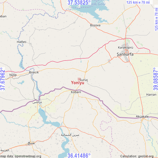
Yonlyu GPS coordinates[2]
36° 58' 43.068" North, 38° 22' 57.864" East
| Map corner | latitude | longitude |
|---|---|---|
| Upper-left | 37.53825°, | 37.67962° |
| Center: | 36.97863°, | 38.38274° |
| Lower-right: | 36.41486°, | 39.08587° |
| Map W x H: | 124.9×124.9 km | = 77.6×77.6mi |
| max Lat: | 42.02683° ⇑88.4% North |
| Yonlyu: | 36.97863° |
| min Lat: | ⇓11.6% South 35.9025° |
| min Long | Yonlyu | max Long |
| 25.90902° | 38.38274° | 44.60099° |
| W 63.6%⇐ | ⇒36.4% E |
Elevation
Elevation of Yonlyu is 502 m = 1647 ft, and this is 215.4 m = 707 ft below average elevation for this country.
| Max E: |
2682 m = 8799 ft | 60.3% |
| Avg. | 717.4 m = 2354 ft | |
| Yonlyu | 502 m = 1647 ft | |
Min E: |
0 m = 0 ft | 39.7% |
See also: Turkey elevation on elevation.city.
Geographical zone
Yonlyu is located in North temperate zone (between Tropic of Cancer and the Arctic Circle). Distance of this Northern Tropic circle is 1505.7 km =935.6 mi to South.| Distance of | km | miles | from Yonlyu |
|---|---|---|---|
| North Pole | 5895.4 | 3663.2 | to North |
| Arctic Circle | 3289.5 | 2044 | to North |
| Tropic Cancer | 1505.7 | 935.6 | to South |
| Equator | 4111.6 | 2554.8 | to South |


Nearby cities:
15 places around Yonlyu: (largest is in red/bold)
• Akarçay
32.3 km =20.1 mi,  258°
258°
• Arslanlı
25 km =15.5 mi,  272°
272°
• Aşağı Oylum
19.2 km =11.9 mi,  131°
131°
• Binatlı
5 km =3.1 mi,  180°
180°
• Boybeyi
30.7 km =19.1 mi,  107°
107°
• Kanlıavşar
27.2 km =16.9 mi,  346°
346°
• Küçük Ziyaret
8 km =5 mi,  119°
119°
• Küçükkendirci
8.7 km =5.4 mi,  201°
201°
• Mağaralı
27.4 km =17 mi, 267°
• Mürşitpınar
9 km =5.6 mi, 200°
• Payamlı
21.5 km =13.4 mi,  72°
72°
• Suruç
3.8 km =2.4 mi,  94°
94°
• Uysallı
3.1 km =1.9 mi, 180°
• Yukarı Çaykuyu
32.8 km =20.4 mi, 86°
• Yıldız
5.1 km =3.2 mi,  152°
152°
Sources, notices
• [Note1] Compared only with cities in Turkey existing in our database
• [Src1] Map data: © OpenStreetMap contributors (CC-BY-SA)
• [Src2] Other city data from geonames.org with taken over terms of usage.
• [Src3] Geographical zone / Annual Mean Temperature by Robert A. Rohde @ Wikipedia
