Payamlı geodata
Payamlı (Şanlıurfa) is a seat of a third-order administrative division; located in Turkey in Europe/Istanbul (GMT+3) time zone. In our database, there are 1323 cities with bigger population. Compared to other cities in Turkey, 87.2% of cities are located further ↑North; 64.7% of cities are located further ←West and 51.8% of cities have higher elevation than Payamlı. Note1


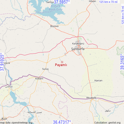
Payamlı GPS coordinates[2]
37° 2' 11.436" North, 38° 36' 48.132" East
| Map corner | latitude | longitude |
|---|---|---|
| Upper-left | 37.5957°, | 37.91025° |
| Center: | 37.03651°, | 38.61337° |
| Lower-right: | 36.47317°, | 39.3165° |
| Map W x H: | 124.8×124.8 km | = 77.5×77.5mi |
| max Lat: | 42.02683° ⇑87.2% North |
| Payamlı: | 37.03651° |
| min Lat: | ⇓12.8% South 35.9025° |
| min Long | Payamlı | max Long |
| 25.90902° | 38.61337° | 44.60099° |
| W 64.7%⇐ | ⇒35.3% E |
Elevation
Elevation of Payamlı is 660 m = 2165 ft, and this is 57.4 m = 188 ft below average elevation for this country.
| Max E: |
2682 m = 8799 ft | 51.8% |
| Avg. | 717.4 m = 2354 ft | |
| Payamlı | 660 m = 2165 ft | |
Min E: |
0 m = 0 ft | 48.2% |
See also: Turkey elevation on elevation.city.
Geographical zone
Payamlı is located in North temperate zone (between Tropic of Cancer and the Arctic Circle). Distance of this Northern Tropic circle is 1512.2 km =939.6 mi to South.| Distance of | km | miles | from Payamlı |
|---|---|---|---|
| North Pole | 5889 | 3659.3 | to North |
| Arctic Circle | 3283.1 | 2040 | to North |
| Tropic Cancer | 1512.2 | 939.6 | to South |
| Equator | 4118.1 | 2558.9 | to South |


Nearby cities:
15 places around Payamlı: (largest is in red/bold)
• Aşağı Oylum
20.1 km =12.5 mi,  197°
197°
• Binatlı
23.5 km =14.6 mi,  240°
240°
• Boybeyi
17.8 km =11.1 mi,  150°
150°
• Karaköprü
24.8 km =15.4 mi,  41°
41°
• Küçük Ziyaret
17 km =10.6 mi,  232°
232°
• Küçükkendirci
27.8 km =17.3 mi, 238°
• Milköy
26.3 km =16.3 mi,  144°
144°
• Ozanlar
27.3 km =17 mi,  111°
111°
• Suruç
18 km =11.2 mi,  248°
248°
• Uysallı
22.6 km =14 mi, 245°
• Yonlyu
21.5 km =13.4 mi, 252°
• Yukarı Çaykuyu
13.1 km =8.1 mi, 110°
• Yıldız
21.2 km =13.2 mi, 238°
• Şanlıurfa
21.6 km =13.4 mi,  47°
47°
• Şehit Nusretbey
23.7 km =14.7 mi, 152°
Sources, notices
• [Note1] Compared only with cities in Turkey existing in our database
• [Src1] Map data: © OpenStreetMap contributors (CC-BY-SA)
• [Src2] Other city data from geonames.org with taken over terms of usage.
• [Src3] Geographical zone / Annual Mean Temperature by Robert A. Rohde @ Wikipedia
