Kösetarla geodata
Kösetarla (Batman) is a populated place; located in Turkey in Europe/Istanbul (GMT+3) time zone. With population of 720 people, there are 1194 cities with bigger population in this country. Compared to other cities in Turkey, 65.4% of cities are located further ↑North; 83% of cities are located further ←West and 51.4% of cities have higher elevation than Kösetarla. Note1


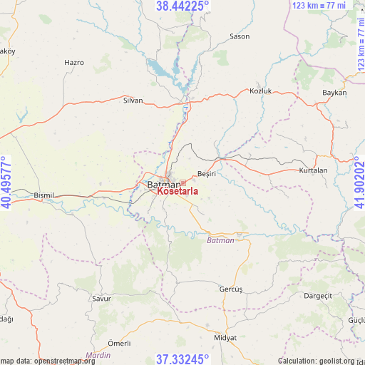
Kösetarla GPS coordinates[2]
37° 53' 21.984" North, 41° 11' 56.004" East
| Map corner | latitude | longitude |
|---|---|---|
| Upper-left | 38.44225°, | 40.49577° |
| Center: | 37.88944°, | 41.19889° |
| Lower-right: | 37.33245°, | 41.90202° |
| Map W x H: | 123.4×123.4 km | = 76.7×76.7mi |
| max Lat: | 42.02683° ⇑65.4% North |
| Kösetarla: | 37.88944° |
| min Lat: | ⇓34.6% South 35.9025° |
| min Long | Kösetarla | max Long |
| 25.90902° | 41.19889° | 44.60099° |
| W 83%⇐ | ⇒17% E |
Elevation
Elevation of Kösetarla is 670 m = 2198 ft, and this is 47.4 m = 156 ft below average elevation for this country.
| Max E: |
2682 m = 8799 ft | 51.4% |
| Avg. | 717.4 m = 2354 ft | |
| Kösetarla | 670 m = 2198 ft | |
Min E: |
0 m = 0 ft | 48.6% |
See also: Turkey elevation on elevation.city.
Geographical zone
Kösetarla is located in North temperate zone (between Tropic of Cancer and the Arctic Circle). Distance of this Northern Tropic circle is 1607 km =998.5 mi to South.| Distance of | km | miles | from Kösetarla |
|---|---|---|---|
| North Pole | 5794.2 | 3600.3 | to North |
| Arctic Circle | 3188.3 | 1981.1 | to North |
| Tropic Cancer | 1607 | 998.5 | to South |
| Equator | 4212.9 | 2617.8 | to South |


Nearby cities:
15 places around Kösetarla: (largest is in red/bold)
• Akça
4.2 km =2.6 mi,  199°
199°
• Aydınkonak
3.1 km =1.9 mi,  280°
280°
• Batman
5.9 km =3.7 mi,  267°
267°
• Beşiri
8.2 km =5.1 mi,  69°
69°
• Binatlı
4.9 km =3 mi,  162°
162°
• Danalı
5.2 km =3.2 mi,  98°
98°
• Demirlipınar
8.3 km =5.2 mi,  345°
345°
• Demiryol
5.3 km =3.3 mi,  305°
305°
• Doğankavak
8.5 km =5.3 mi,  16°
16°
• Erköklü
5.7 km =3.5 mi,  237°
237°
• Karayün
9.6 km =6 mi,  230°
230°
• Yenipınar
10.4 km =6.5 mi,  119°
119°
• Yontukyazı
11.4 km =7.1 mi,  93°
93°
• Çevrimova
8.5 km =5.3 mi,  130°
130°
• İkiztepe
10 km =6.2 mi, 272°
Sources, notices
• [Note1] Compared only with cities in Turkey existing in our database
• [Src1] Map data: © OpenStreetMap contributors (CC-BY-SA)
• [Src2] Other city data from geonames.org with taken over terms of usage.
• [Src3] Geographical zone / Annual Mean Temperature by Robert A. Rohde @ Wikipedia
