İkiztepe geodata
İkiztepe (Batman) is a populated place; located in Turkey in Europe/Istanbul (GMT+3) time zone. With population of 990 people, there are 1093 cities with bigger population in this country. Compared to other cities in Turkey, 65.2% of cities are located further ↑North; 82.2% of cities are located further ←West and 57.5% of cities have higher elevation than İkiztepe. Note1


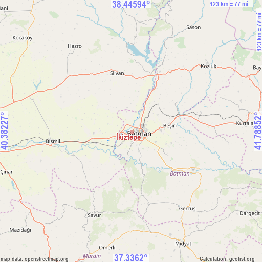
İkiztepe GPS coordinates[2]
37° 53' 35.376" North, 41° 5' 7.404" East
| Map corner | latitude | longitude |
|---|---|---|
| Upper-left | 38.44594°, | 40.38227° |
| Center: | 37.89316°, | 41.08539° |
| Lower-right: | 37.3362°, | 41.78852° |
| Map W x H: | 123.4×123.4 km | = 76.7×76.7mi |
| max Lat: | 42.02683° ⇑65.2% North |
| İkiztepe: | 37.89316° |
| min Lat: | ⇓34.8% South 35.9025° |
| min Long | İkiztepe | max Long |
| 25.90902° | 41.08539° | 44.60099° |
| W 82.2%⇐ | ⇒17.8% E |
Elevation
Elevation of İkiztepe is 548 m = 1798 ft, and this is 169.4 m = 556 ft below average elevation for this country.
| Max E: |
2682 m = 8799 ft | 57.5% |
| Avg. | 717.4 m = 2354 ft | |
| İkiztepe | 548 m = 1798 ft | |
Min E: |
0 m = 0 ft | 42.5% |
See also: Turkey elevation on elevation.city.
Geographical zone
İkiztepe is located in North temperate zone (between Tropic of Cancer and the Arctic Circle). Distance of this Northern Tropic circle is 1607.4 km =998.8 mi to South.| Distance of | km | miles | from İkiztepe |
|---|---|---|---|
| North Pole | 5793.7 | 3600 | to North |
| Arctic Circle | 3187.8 | 1980.8 | to North |
| Tropic Cancer | 1607.4 | 998.8 | to South |
| Equator | 4213.3 | 2618 | to South |


Nearby cities:
15 places around İkiztepe: (largest is in red/bold)
• Akbaş
9.6 km =6 mi,  346°
346°
• Akoba
6.2 km =3.9 mi,  334°
334°
• Akça
9.6 km =6 mi,  116°
116°
• Aydınkonak
6.9 km =4.3 mi,  88°
88°
• Bademli
11.5 km =7.1 mi,  288°
288°
• Balpınar
3.8 km =2.4 mi,  223°
223°
• Batman
4.2 km =2.6 mi,  98°
98°
• Demirlipınar
11 km =6.8 mi,  46°
46°
• Demiryol
6.3 km =3.9 mi,  64°
64°
• Diktepe
3.6 km =2.2 mi,  324°
324°
• Erköklü
6.2 km =3.9 mi, 124°
• Karayün
6.9 km =4.3 mi,  158°
158°
• Kösetarla
10 km =6.2 mi, 92°
• Sinanköy
8.8 km =5.5 mi,  246°
246°
• Yeniköy
3.4 km =2.1 mi, 245°
Sources, notices
• [Note1] Compared only with cities in Turkey existing in our database
• [Src1] Map data: © OpenStreetMap contributors (CC-BY-SA)
• [Src2] Other city data from geonames.org with taken over terms of usage.
• [Src3] Geographical zone / Annual Mean Temperature by Robert A. Rohde @ Wikipedia
