Binatlı geodata
Binatlı (Batman) is a populated place; located in Turkey in Europe/Istanbul (GMT+3) time zone. With population of 2,259 people, there are 917 cities with bigger population in this country. Compared to other cities in Turkey, 67.1% of cities are located further ↑North; 83.1% of cities are located further ←West and 52.7% of cities have higher elevation than Binatlı. Note1


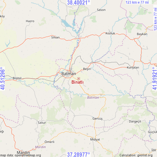
Binatlı GPS coordinates[2]
37° 50' 49.488" North, 41° 12' 57.888" East
| Map corner | latitude | longitude |
|---|---|---|
| Upper-left | 38.40021°, | 40.51296° |
| Center: | 37.84708°, | 41.21608° |
| Lower-right: | 37.28977°, | 41.91921° |
| Map W x H: | 123.5×123.5 km | = 76.7×76.7mi |
| max Lat: | 42.02683° ⇑67.1% North |
| Binatlı: | 37.84708° |
| min Lat: | ⇓32.9% South 35.9025° |
| min Long | Binatlı | max Long |
| 25.90902° | 41.21608° | 44.60099° |
| W 83.1%⇐ | ⇒16.9% E |
Elevation
Elevation of Binatlı is 640 m = 2100 ft, and this is 77.4 m = 254 ft below average elevation for this country.
| Max E: |
2682 m = 8799 ft | 52.7% |
| Avg. | 717.4 m = 2354 ft | |
| Binatlı | 640 m = 2100 ft | |
Min E: |
0 m = 0 ft | 47.3% |
See also: Turkey elevation on elevation.city.
Geographical zone
Binatlı is located in North temperate zone (between Tropic of Cancer and the Arctic Circle). Distance of this Northern Tropic circle is 1602.3 km =995.6 mi to South.| Distance of | km | miles | from Binatlı |
|---|---|---|---|
| North Pole | 5798.9 | 3603.3 | to North |
| Arctic Circle | 3193 | 1984 | to North |
| Tropic Cancer | 1602.3 | 995.6 | to South |
| Equator | 4208.2 | 2614.9 | to South |


Nearby cities:
15 places around Binatlı: (largest is in red/bold)
• Akça
3 km =1.9 mi,  285°
285°
• Aydınkonak
7 km =4.3 mi,  319°
319°
• Batman
8.6 km =5.3 mi,  301°
301°
• Beşiri
9.8 km =6.1 mi,  38°
38°
• Danalı
5.3 km =3.3 mi, 42°
• Demirlipınar
13.2 km =8.2 mi,  344°
344°
• Demiryol
9.8 km =6.1 mi, 323°
• Doğankavak
12.9 km =8 mi,  4°
4°
• Erköklü
6.5 km =4 mi,  284°
284°
• Karayün
9.1 km =5.7 mi,  261°
261°
• Kösetarla
4.9 km =3 mi, 342°
• Yenipınar
7.5 km =4.7 mi,  93°
93°
• Yontukyazı
10.7 km =6.6 mi,  67°
67°
• Çevrimova
5 km =3.1 mi,  98°
98°
• İkiztepe
12.6 km =7.8 mi, 294°
Sources, notices
• [Note1] Compared only with cities in Turkey existing in our database
• [Src1] Map data: © OpenStreetMap contributors (CC-BY-SA)
• [Src2] Other city data from geonames.org with taken over terms of usage.
• [Src3] Geographical zone / Annual Mean Temperature by Robert A. Rohde @ Wikipedia
