Danalı geodata
Danalı (Batman) is a populated place; located in Turkey in Europe/Istanbul (GMT+3) time zone. With population of 596 people, there are 1255 cities with bigger population in this country. Compared to other cities in Turkey, 66% of cities are located further ↑North; 83.6% of cities are located further ←West and 53.1% of cities have lower elevation than Danalı. Note1


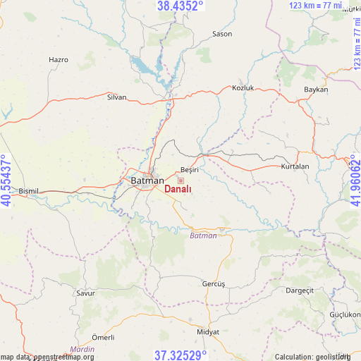
Danalı GPS coordinates[2]
37° 52' 56.424" North, 41° 15' 26.964" East
| Map corner | latitude | longitude |
|---|---|---|
| Upper-left | 38.4352°, | 40.55437° |
| Center: | 37.88234°, | 41.25749° |
| Lower-right: | 37.32529°, | 41.96062° |
| Map W x H: | 123.4×123.4 km | = 76.7×76.7mi |
| max Lat: | 42.02683° ⇑66% North |
| Danalı: | 37.88234° |
| min Lat: | ⇓34% South 35.9025° |
| min Long | Danalı | max Long |
| 25.90902° | 41.25749° | 44.60099° |
| W 83.6%⇐ | ⇒16.4% E |
Elevation
Elevation of Danalı is 758 m = 2487 ft, and this is 40.6 m = 133 ft above average elevation for this country.
| Max E: |
2682 m = 8799 ft | 46.9% |
| Danalı | 758 m 2487 ft | |
| Avg. | 717.4 m = 2354 ft | |
Min E: |
0 m = 0 ft | 53.1% |
See also: Turkey elevation on elevation.city.
Geographical zone
Danalı is located in North temperate zone (between Tropic of Cancer and the Arctic Circle). Distance of this Northern Tropic circle is 1606.2 km =998 mi to South.| Distance of | km | miles | from Danalı |
|---|---|---|---|
| North Pole | 5794.9 | 3600.8 | to North |
| Arctic Circle | 3189.1 | 1981.6 | to North |
| Tropic Cancer | 1606.2 | 998 | to South |
| Equator | 4212.1 | 2617.3 | to South |


Nearby cities:
15 places around Danalı: (largest is in red/bold)
• Akça
7.3 km =4.5 mi,  244°
244°
• Asmadere
10.2 km =6.3 mi,  72°
72°
• Aviski
11.2 km =7 mi,  35°
35°
• Aydınkonak
8.3 km =5.2 mi,  279°
279°
• Batman
11 km =6.8 mi,  272°
272°
• Beşiri
4.5 km =2.8 mi,  34°
34°
• Binatlı
5.3 km =3.3 mi,  222°
222°
• Demirlipınar
11.3 km =7 mi,  320°
320°
• Demiryol
10.2 km =6.3 mi,  292°
292°
• Doğankavak
9.3 km =5.8 mi,  343°
343°
• Erköklü
10.2 km =6.3 mi,  257°
257°
• Kösetarla
5.2 km =3.2 mi, 278°
• Yenipınar
5.8 km =3.6 mi,  138°
138°
• Yontukyazı
6.3 km =3.9 mi,  88°
88°
• Çevrimova
4.9 km =3 mi,  163°
163°
Sources, notices
• [Note1] Compared only with cities in Turkey existing in our database
• [Src1] Map data: © OpenStreetMap contributors (CC-BY-SA)
• [Src2] Other city data from geonames.org with taken over terms of usage.
• [Src3] Geographical zone / Annual Mean Temperature by Robert A. Rohde @ Wikipedia
