Akoba geodata
Akoba (Diyarbakır) is a populated place; located in Turkey in Europe/Istanbul (GMT+3) time zone. With population of 794 people, there are 1153 cities with bigger population in this country. Compared to other cities in Turkey, 63.1% of cities are located further ↑North; 81.9% of cities are located further ←West and 51.5% of cities have higher elevation than Akoba. Note1


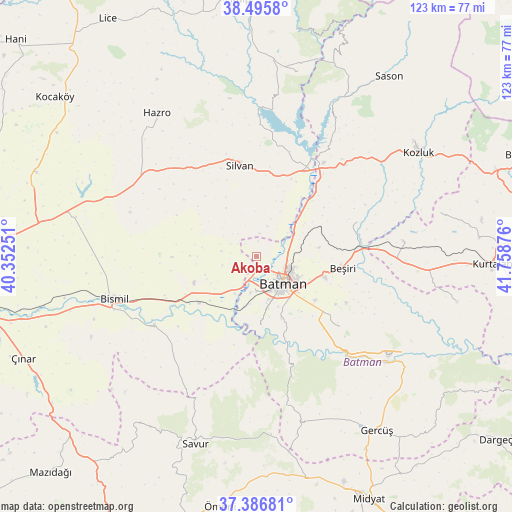
Akoba GPS coordinates[2]
37° 56' 36.24" North, 41° 3' 20.268" East
| Map corner | latitude | longitude |
|---|---|---|
| Upper-left | 38.4958°, | 40.35251° |
| Center: | 37.9434°, | 41.05563° |
| Lower-right: | 37.38681°, | 41.75876° |
| Map W x H: | 123.3×123.3 km | = 76.6×76.6mi |
| max Lat: | 42.02683° ⇑63.1% North |
| Akoba: | 37.9434° |
| min Lat: | ⇓36.9% South 35.9025° |
| min Long | Akoba | max Long |
| 25.90902° | 41.05563° | 44.60099° |
| W 81.9%⇐ | ⇒18.1% E |
Elevation
Elevation of Akoba is 667 m = 2188 ft, and this is 50.4 m = 165 ft below average elevation for this country.
| Max E: |
2682 m = 8799 ft | 51.5% |
| Avg. | 717.4 m = 2354 ft | |
| Akoba | 667 m = 2188 ft | |
Min E: |
0 m = 0 ft | 48.5% |
See also: Turkey elevation on elevation.city.
Geographical zone
Akoba is located in North temperate zone (between Tropic of Cancer and the Arctic Circle). Distance of this Northern Tropic circle is 1613 km =1002.3 mi to South.| Distance of | km | miles | from Akoba |
|---|---|---|---|
| North Pole | 5788.2 | 3596.6 | to North |
| Arctic Circle | 3182.3 | 1977.4 | to North |
| Tropic Cancer | 1613 | 1002.3 | to South |
| Equator | 4218.9 | 2621.5 | to South |


Nearby cities:
15 places around Akoba: (largest is in red/bold)
• Akbaş
3.8 km =2.4 mi,  4°
4°
• Akçayır
7.8 km =4.8 mi,  312°
312°
• Aydınkonak
10.9 km =6.8 mi,  119°
119°
• Bademli
8.5 km =5.3 mi,  256°
256°
• Balpınar
8.4 km =5.2 mi,  180°
180°
• Batman
9.2 km =5.7 mi,  132°
132°
• Demirlipınar
10.7 km =6.6 mi,  79°
79°
• Demiryol
8.7 km =5.4 mi,  109°
109°
• Diktepe
2.7 km =1.7 mi,  169°
169°
• Erköklü
11.9 km =7.4 mi,  139°
139°
• Karayün
13.1 km =8.1 mi,  157°
157°
• Kopuzlu
8.5 km =5.3 mi,  277°
277°
• Sinanköy
10.6 km =6.6 mi,  211°
211°
• Yeniköy
7 km =4.3 mi, 184°
• İkiztepe
6.2 km =3.9 mi,  154°
154°
Sources, notices
• [Note1] Compared only with cities in Turkey existing in our database
• [Src1] Map data: © OpenStreetMap contributors (CC-BY-SA)
• [Src2] Other city data from geonames.org with taken over terms of usage.
• [Src3] Geographical zone / Annual Mean Temperature by Robert A. Rohde @ Wikipedia
