Balpınar geodata
Balpınar (Batman) is a populated place; located in Turkey in Europe/Istanbul (GMT+3) time zone. With population of 2,879 people, there are 867 cities with bigger population in this country. Compared to other cities in Turkey, 66.4% of cities are located further ↑North; 81.9% of cities are located further ←West and 58% of cities have higher elevation than Balpınar. Note1


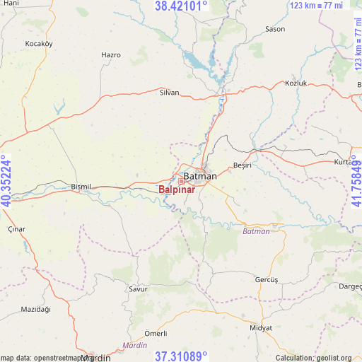
Balpınar GPS coordinates[2]
37° 52' 4.944" North, 41° 3' 19.296" East
| Map corner | latitude | longitude |
|---|---|---|
| Upper-left | 38.42101°, | 40.35224° |
| Center: | 37.86804°, | 41.05536° |
| Lower-right: | 37.31089°, | 41.75849° |
| Map W x H: | 123.4×123.4 km | = 76.7×76.7mi |
| max Lat: | 42.02683° ⇑66.4% North |
| Balpınar: | 37.86804° |
| min Lat: | ⇓33.6% South 35.9025° |
| min Long | Balpınar | max Long |
| 25.90902° | 41.05536° | 44.60099° |
| W 81.9%⇐ | ⇒18.1% E |
Elevation
Elevation of Balpınar is 538 m = 1765 ft, and this is 179.4 m = 589 ft below average elevation for this country.
| Max E: |
2682 m = 8799 ft | 58% |
| Avg. | 717.4 m = 2354 ft | |
| Balpınar | 538 m = 1765 ft | |
Min E: |
0 m = 0 ft | 42% |
See also: Turkey elevation on elevation.city.
Geographical zone
Balpınar is located in North temperate zone (between Tropic of Cancer and the Arctic Circle). Distance of this Northern Tropic circle is 1604.6 km =997.1 mi to South.| Distance of | km | miles | from Balpınar |
|---|---|---|---|
| North Pole | 5796.5 | 3601.8 | to North |
| Arctic Circle | 3190.6 | 1982.5 | to North |
| Tropic Cancer | 1604.6 | 997.1 | to South |
| Equator | 4210.5 | 2616.3 | to South |


Nearby cities:
15 places around Balpınar: (largest is in red/bold)
• Akbaş
12.1 km =7.5 mi,  1°
1°
• Akoba
8.4 km =5.2 mi, 0°
• Akça
11.3 km =7 mi,  97°
97°
• Aydınkonak
10 km =6.2 mi,  72°
72°
• Bademli
10.5 km =6.5 mi,  307°
307°
• Batman
7.1 km =4.4 mi, 72°
• Demiryol
9.9 km =6.2 mi,  56°
56°
• Diktepe
5.8 km =3.6 mi,  5°
5°
• Erköklü
7.8 km =4.8 mi, 95°
• Karayün
6.3 km =3.9 mi,  125°
125°
• Kopuzlu
12.7 km =7.9 mi,  318°
318°
• Oymataş
8.3 km =5.2 mi,  201°
201°
• Sinanköy
5.5 km =3.4 mi,  262°
262°
• Yeniköy
1.5 km =0.9 mi,  341°
341°
• İkiztepe
3.8 km =2.4 mi,  43°
43°
Sources, notices
• [Note1] Compared only with cities in Turkey existing in our database
• [Src1] Map data: © OpenStreetMap contributors (CC-BY-SA)
• [Src2] Other city data from geonames.org with taken over terms of usage.
• [Src3] Geographical zone / Annual Mean Temperature by Robert A. Rohde @ Wikipedia
