Asmadere geodata
Asmadere (Batman) is a populated place; located in Turkey in Europe/Istanbul (GMT+3) time zone. With population of 529 people, there are 1293 cities with bigger population in this country. Compared to other cities in Turkey, 64.6% of cities are located further ↑North; 85% of cities are located further ←West and 55.1% of cities have higher elevation than Asmadere. Note1


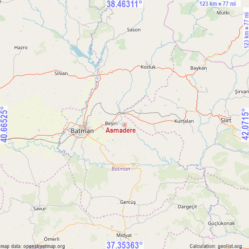
Asmadere GPS coordinates[2]
37° 54' 37.656" North, 41° 22' 6.132" East
| Map corner | latitude | longitude |
|---|---|---|
| Upper-left | 38.46311°, | 40.66525° |
| Center: | 37.91046°, | 41.36837° |
| Lower-right: | 37.35363°, | 42.0715° |
| Map W x H: | 123.4×123.4 km | = 76.7×76.7mi |
| max Lat: | 42.02683° ⇑64.6% North |
| Asmadere: | 37.91046° |
| min Lat: | ⇓35.4% South 35.9025° |
| min Long | Asmadere | max Long |
| 25.90902° | 41.36837° | 44.60099° |
| W 85%⇐ | ⇒15% E |
Elevation
Elevation of Asmadere is 585 m = 1919 ft, and this is 132.4 m = 434 ft below average elevation for this country.
| Max E: |
2682 m = 8799 ft | 55.1% |
| Avg. | 717.4 m = 2354 ft | |
| Asmadere | 585 m = 1919 ft | |
Min E: |
0 m = 0 ft | 44.9% |
See also: Turkey elevation on elevation.city.
Geographical zone
Asmadere is located in North temperate zone (between Tropic of Cancer and the Arctic Circle). Distance of this Northern Tropic circle is 1609.3 km =1000 mi to South.| Distance of | km | miles | from Asmadere |
|---|---|---|---|
| North Pole | 5791.8 | 3598.9 | to North |
| Arctic Circle | 3185.9 | 1979.6 | to North |
| Tropic Cancer | 1609.3 | 1000 | to South |
| Equator | 4215.2 | 2619.2 | to South |


Nearby cities:
15 places around Asmadere: (largest is in red/bold)
• Aviski
6.8 km =4.2 mi,  331°
331°
• Beyçayırı
12.2 km =7.6 mi,  341°
341°
• Beşiri
7.2 km =4.5 mi,  274°
274°
• Binatlı
15.1 km =9.4 mi,  242°
242°
• Danalı
10.2 km =6.3 mi,  252°
252°
• Doğankavak
13.7 km =8.5 mi,  295°
295°
• Gökdoğan
5.7 km =3.5 mi,  33°
33°
• Gözpınar
10.8 km =6.7 mi,  46°
46°
• Kösetarla
15.1 km =9.4 mi,  261°
261°
• Oğuz
10.6 km =6.6 mi,  177°
177°
• Saipbeyli
15.8 km =9.8 mi, 52°
• Taliban
8.8 km =5.5 mi, 26°
• Yenipınar
9.5 km =5.9 mi,  218°
218°
• Yontukyazı
4.6 km =2.9 mi,  229°
229°
• Çevrimova
11.5 km =7.1 mi, 226°
Sources, notices
• [Note1] Compared only with cities in Turkey existing in our database
• [Src1] Map data: © OpenStreetMap contributors (CC-BY-SA)
• [Src2] Other city data from geonames.org with taken over terms of usage.
• [Src3] Geographical zone / Annual Mean Temperature by Robert A. Rohde @ Wikipedia
