Shaklan geodata
Shaklan (Mardin) is a populated place; located in Turkey in Europe/Istanbul (GMT+3) time zone. With population of 624 people, there are 1237 cities with bigger population in this country. Compared to other cities in Turkey, 84.8% of cities are located further ↑North; 79.1% of cities are located further ←West and 59.2% of cities have higher elevation than Shaklan. Note1


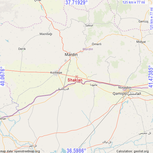
Shaklan GPS coordinates[2]
37° 9' 39.672" North, 40° 46' 14.592" East
| Map corner | latitude | longitude |
|---|---|---|
| Upper-left | 37.71929°, | 40.0676° |
| Center: | 37.16102°, | 40.77072° |
| Lower-right: | 36.5986°, | 41.47385° |
| Map W x H: | 124.6×124.6 km | = 77.4×77.4mi |
| max Lat: | 42.02683° ⇑84.8% North |
| Shaklan: | 37.16102° |
| min Lat: | ⇓15.2% South 35.9025° |
| min Long | Shaklan | max Long |
| 25.90902° | 40.77072° | 44.60099° |
| W 79.1%⇐ | ⇒20.9% E |
Elevation
Elevation of Shaklan is 519 m = 1703 ft, and this is 198.4 m = 651 ft below average elevation for this country.
| Max E: |
2682 m = 8799 ft | 59.2% |
| Avg. | 717.4 m = 2354 ft | |
| Shaklan | 519 m = 1703 ft | |
Min E: |
0 m = 0 ft | 40.8% |
See also: Turkey elevation on elevation.city.
Geographical zone
Shaklan is located in North temperate zone (between Tropic of Cancer and the Arctic Circle). Distance of this Northern Tropic circle is 1526 km =948.2 mi to South.| Distance of | km | miles | from Shaklan |
|---|---|---|---|
| North Pole | 5875.1 | 3650.6 | to North |
| Arctic Circle | 3269.3 | 2031.4 | to North |
| Tropic Cancer | 1526 | 948.2 | to South |
| Equator | 4131.9 | 2567.4 | to South |


Nearby cities:
15 places around Shaklan: (largest is in red/bold)
• Akıncı
6.8 km =4.2 mi,  84°
84°
• Arpatepe
3.5 km =2.2 mi,  136°
136°
• Boztepe
5.3 km =3.3 mi,  298°
298°
• Elbeyli
11.5 km =7.1 mi,  282°
282°
• Eskin
10.2 km =6.3 mi,  306°
306°
• Eymirli
7.5 km =4.7 mi, 277°
• Eşme
11.5 km =7.1 mi,  267°
267°
• Göllü
11.2 km =7 mi,  333°
333°
• Hatunlu
2.8 km =1.7 mi,  211°
211°
• Kumlu
3.4 km =2.1 mi,  291°
291°
• Kuyulu
2 km =1.2 mi,  98°
98°
• Ortaköy
6.8 km =4.2 mi,  10°
10°
• Selah
8.2 km =5.1 mi, 307°
• Yaylı
4.9 km =3 mi,  342°
342°
• Yukarı Aydınlı
11.4 km =7.1 mi,  90°
90°
Sources, notices
• [Note1] Compared only with cities in Turkey existing in our database
• [Src1] Map data: © OpenStreetMap contributors (CC-BY-SA)
• [Src2] Other city data from geonames.org with taken over terms of usage.
• [Src3] Geographical zone / Annual Mean Temperature by Robert A. Rohde @ Wikipedia
