Arpatepe geodata
Arpatepe (Mardin) is a populated place; located in Turkey in Europe/Istanbul (GMT+3) time zone. With population of 656 people, there are 1222 cities with bigger population in this country. Compared to other cities in Turkey, 85.5% of cities are located further ↑North; 79.5% of cities are located further ←West and 60.5% of cities have higher elevation than Arpatepe. Note1


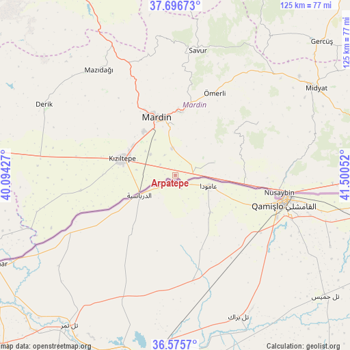
Arpatepe GPS coordinates[2]
37° 8' 17.844" North, 40° 47' 50.604" East
| Map corner | latitude | longitude |
|---|---|---|
| Upper-left | 37.69673°, | 40.09427° |
| Center: | 37.13829°, | 40.79739° |
| Lower-right: | 36.5757°, | 41.50052° |
| Map W x H: | 124.6×124.6 km | = 77.4×77.4mi |
| max Lat: | 42.02683° ⇑85.5% North |
| Arpatepe: | 37.13829° |
| min Lat: | ⇓14.5% South 35.9025° |
| min Long | Arpatepe | max Long |
| 25.90902° | 40.79739° | 44.60099° |
| W 79.5%⇐ | ⇒20.5% E |
Elevation
Elevation of Arpatepe is 499 m = 1637 ft, and this is 218.4 m = 717 ft below average elevation for this country.
| Max E: |
2682 m = 8799 ft | 60.5% |
| Avg. | 717.4 m = 2354 ft | |
| Arpatepe | 499 m = 1637 ft | |
Min E: |
0 m = 0 ft | 39.5% |
See also: Turkey elevation on elevation.city.
Geographical zone
Arpatepe is located in North temperate zone (between Tropic of Cancer and the Arctic Circle). Distance of this Northern Tropic circle is 1523.5 km =946.7 mi to South.| Distance of | km | miles | from Arpatepe |
|---|---|---|---|
| North Pole | 5877.7 | 3652.2 | to North |
| Arctic Circle | 3271.8 | 2033 | to North |
| Tropic Cancer | 1523.5 | 946.7 | to South |
| Equator | 4129.4 | 2565.9 | to South |


Nearby cities:
15 places around Arpatepe: (largest is in red/bold)
• Akıncı
5.4 km =3.4 mi,  54°
54°
• Boztepe
8.6 km =5.3 mi,  305°
305°
• Doyuran
14.3 km =8.9 mi,  263°
263°
• Elbeyli
14.5 km =9 mi,  290°
290°
• Eskin
13.6 km =8.5 mi, 309°
• Eymirli
10.4 km =6.5 mi, 289°
• Eşme
14 km =8.7 mi,  277°
277°
• Hatunlu
3.8 km =2.4 mi,  271°
271°
• Kumlu
6.7 km =4.2 mi,  304°
304°
• Kuyulu
2.3 km =1.4 mi,  349°
349°
• Ortaköy
9.3 km =5.8 mi, 353°
• Selah
11.6 km =7.2 mi, 310°
• Shaklan
3.5 km =2.2 mi,  316°
316°
• Yaylı
8.2 km =5.1 mi,  331°
331°
• Yukarı Aydınlı
9.3 km =5.8 mi,  75°
75°
Sources, notices
• [Note1] Compared only with cities in Turkey existing in our database
• [Src1] Map data: © OpenStreetMap contributors (CC-BY-SA)
• [Src2] Other city data from geonames.org with taken over terms of usage.
• [Src3] Geographical zone / Annual Mean Temperature by Robert A. Rohde @ Wikipedia
