Cinatamiho geodata
Cinatamiho (Mardin) is a populated place; located in Turkey in Europe/Istanbul (GMT+3) time zone. With population of 1,066 people, there are 1075 cities with bigger population in this country. Compared to other cities in Turkey, 81% of cities are located further ↑North; 81.6% of cities are located further ←West and 64.5% of cities have lower elevation than Cinatamiho. Note1


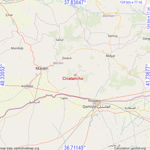
Cinatamiho GPS coordinates[2]
37° 16' 22.944" North, 41° 2' 1.104" East
| Map corner | latitude | longitude |
|---|---|---|
| Upper-left | 37.83047°, | 40.33052° |
| Center: | 37.27304°, | 41.03364° |
| Lower-right: | 36.71145°, | 41.73677° |
| Map W x H: | 124.4×124.4 km | = 77.3×77.3mi |
| max Lat: | 42.02683° ⇑81% North |
| Cinatamiho: | 37.27304° |
| min Lat: | ⇓19% South 35.9025° |
| min Long | Cinatamiho | max Long |
| 25.90902° | 41.03364° | 44.60099° |
| W 81.6%⇐ | ⇒18.4% E |
Elevation
Elevation of Cinatamiho is 950 m = 3117 ft, and this is 232.6 m = 763 ft above average elevation for this country.
| Max E: |
2682 m = 8799 ft | 35.5% |
| Cinatamiho | 950 m 3117 ft | |
| Avg. | 717.4 m = 2354 ft | |
Min E: |
0 m = 0 ft | 64.5% |
See also: Turkey elevation on elevation.city.
Geographical zone
Cinatamiho is located in North temperate zone (between Tropic of Cancer and the Arctic Circle). Distance of this Northern Tropic circle is 1538.5 km =956 mi to South.| Distance of | km | miles | from Cinatamiho |
|---|---|---|---|
| North Pole | 5862.7 | 3642.9 | to North |
| Arctic Circle | 3256.8 | 2023.7 | to North |
| Tropic Cancer | 1538.5 | 956 | to South |
| Equator | 4144.4 | 2575.2 | to South |


Nearby cities:
15 places around Cinatamiho: (largest is in red/bold)
• Akarsu
5.4 km =3.4 mi,  163°
163°
• Akıncı
20.3 km =12.6 mi,  234°
234°
• Dallıağaç
3.7 km =2.3 mi,  39°
39°
• Dara
12.6 km =7.8 mi,  213°
213°
• Kabala
22.1 km =13.7 mi,  291°
291°
• Kayalıpınar
18.3 km =11.4 mi,  69°
69°
• Kaynakkaya
11.6 km =7.2 mi,  309°
309°
• Kutlubey
13.3 km =8.3 mi, 73°
• Ortaköy
22.8 km =14.2 mi,  255°
255°
• Toptepe
19.1 km =11.9 mi,  93°
93°
• Yeşilli
20.4 km =12.7 mi, 290°
• Yukarı Aydınlı
17.4 km =10.8 mi,  223°
223°
• Çalpınar
16.9 km =10.5 mi,  52°
52°
• Çınaraltı
19.8 km =12.3 mi, 308°
• Ömerli
15.7 km =9.8 mi,  333°
333°
Sources, notices
• [Note1] Compared only with cities in Turkey existing in our database
• [Src1] Map data: © OpenStreetMap contributors (CC-BY-SA)
• [Src2] Other city data from geonames.org with taken over terms of usage.
• [Src3] Geographical zone / Annual Mean Temperature by Robert A. Rohde @ Wikipedia
