Kaynakkaya geodata
Kaynakkaya (Mardin) is a populated place; located in Turkey in Europe/Istanbul (GMT+3) time zone. With population of 1,571 people, there are 1003 cities with bigger population in this country. Compared to other cities in Turkey, 79.2% of cities are located further ↑North; 80.7% of cities are located further ←West and 74.7% of cities have lower elevation than Kaynakkaya. Note1


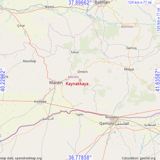
Kaynakkaya GPS coordinates[2]
37° 20' 22.848" North, 40° 55' 57.864" East
| Map corner | latitude | longitude |
|---|---|---|
| Upper-left | 37.89662°, | 40.22962° |
| Center: | 37.33968°, | 40.93274° |
| Lower-right: | 36.77858°, | 41.63587° |
| Map W x H: | 124.3×124.3 km | = 77.2×77.2mi |
| max Lat: | 42.02683° ⇑79.2% North |
| Kaynakkaya: | 37.33968° |
| min Lat: | ⇓20.8% South 35.9025° |
| min Long | Kaynakkaya | max Long |
| 25.90902° | 40.93274° | 44.60099° |
| W 80.7%⇐ | ⇒19.3% E |
Elevation
Elevation of Kaynakkaya is 1099 m = 3606 ft, and this is 381.6 m = 1252 ft above average elevation for this country.
| Max E: |
2682 m = 8799 ft | 25.3% |
| Kaynakkaya | 1099 m 3606 ft | |
| Avg. | 717.4 m = 2354 ft | |
Min E: |
0 m = 0 ft | 74.7% |
See also: Turkey elevation on elevation.city.
Geographical zone
Kaynakkaya is located in North temperate zone (between Tropic of Cancer and the Arctic Circle). Distance of this Northern Tropic circle is 1545.9 km =960.6 mi to South.| Distance of | km | miles | from Kaynakkaya |
|---|---|---|---|
| North Pole | 5855.3 | 3638.3 | to North |
| Arctic Circle | 3249.4 | 2019.1 | to North |
| Tropic Cancer | 1545.9 | 960.6 | to South |
| Equator | 4151.8 | 2579.8 | to South |


Nearby cities:
15 places around Kaynakkaya: (largest is in red/bold)
• Akarsu
16.4 km =10.2 mi,  140°
140°
• Cevizpınarı
13.8 km =8.6 mi,  283°
283°
• Cinatamiho
11.6 km =7.2 mi,  129°
129°
• Dallıağaç
12.1 km =7.5 mi,  112°
112°
• Dara
18 km =11.2 mi,  173°
173°
• Dereyanı
11.6 km =7.2 mi,  326°
326°
• Eryeri
17.3 km =10.7 mi,  253°
253°
• Kabala
11.7 km =7.3 mi,  273°
273°
• Mardin
17 km =10.6 mi,  259°
259°
• Ortaköy
18.6 km =11.6 mi,  224°
224°
• Pınardere
17.1 km =10.6 mi, 329°
• Reshidi
17.5 km =10.9 mi,  10°
10°
• Yeşilli
10.2 km =6.3 mi, 269°
• Çınaraltı
8.2 km =5.1 mi,  307°
307°
• Ömerli
6.9 km =4.3 mi,  16°
16°
Sources, notices
• [Note1] Compared only with cities in Turkey existing in our database
• [Src1] Map data: © OpenStreetMap contributors (CC-BY-SA)
• [Src2] Other city data from geonames.org with taken over terms of usage.
• [Src3] Geographical zone / Annual Mean Temperature by Robert A. Rohde @ Wikipedia
