Akarsu geodata
Akarsu (Mardin) is a seat of a third-order administrative division; located in Turkey in Europe/Istanbul (GMT+3) time zone. With population of 5,440 people, there are 691 cities with bigger population in this country. Compared to other cities in Turkey, 82.4% of cities are located further ↑North; 81.8% of cities are located further ←West and 62.1% of cities have lower elevation than Akarsu. Note1


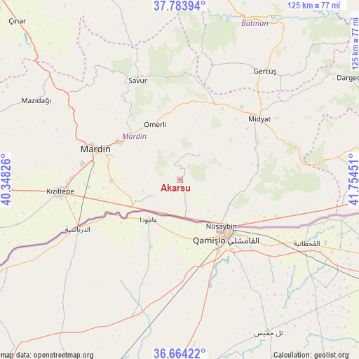
Akarsu GPS coordinates[2]
37° 13' 34.176" North, 41° 3' 4.968" East
| Map corner | latitude | longitude |
|---|---|---|
| Upper-left | 37.78394°, | 40.34826° |
| Center: | 37.22616°, | 41.05138° |
| Lower-right: | 36.66422°, | 41.75451° |
| Map W x H: | 124.5×124.5 km | = 77.4×77.4mi |
| max Lat: | 42.02683° ⇑82.4% North |
| Akarsu: | 37.22616° |
| min Lat: | ⇓17.6% South 35.9025° |
| min Long | Akarsu | max Long |
| 25.90902° | 41.05138° | 44.60099° |
| W 81.8%⇐ | ⇒18.2% E |
Elevation
Elevation of Akarsu is 914 m = 2999 ft, and this is 196.6 m = 645 ft above average elevation for this country.
| Max E: |
2682 m = 8799 ft | 37.9% |
| Akarsu | 914 m 2999 ft | |
| Avg. | 717.4 m = 2354 ft | |
Min E: |
0 m = 0 ft | 62.1% |
See also: Turkey elevation on elevation.city.
Geographical zone
Akarsu is located in North temperate zone (between Tropic of Cancer and the Arctic Circle). Distance of this Northern Tropic circle is 1533.2 km =952.7 mi to South.| Distance of | km | miles | from Akarsu |
|---|---|---|---|
| North Pole | 5867.9 | 3646.1 | to North |
| Arctic Circle | 3262 | 2026.9 | to North |
| Tropic Cancer | 1533.2 | 952.7 | to South |
| Equator | 4139.2 | 2572 | to South |


Nearby cities:
15 places around Akarsu: (largest is in red/bold)
• Akıncı
19.3 km =12 mi,  249°
249°
• Bahçebaşı
20.5 km =12.7 mi,  127°
127°
• Cinatamiho
5.4 km =3.4 mi,  343°
343°
• Dallıağaç
8.1 km =5 mi,  5°
5°
• Dara
10.1 km =6.3 mi,  238°
238°
• Kayalıpınar
19.4 km =12.1 mi,  53°
53°
• Kaynakkaya
16.4 km =10.2 mi,  320°
320°
• Kutlubey
14.3 km =8.9 mi, 51°
• Nusaybin
22.6 km =14 mi,  140°
140°
• Ortaköy
23.6 km =14.7 mi,  268°
268°
• Toptepe
18 km =11.2 mi,  77°
77°
• Yukarı Aydınlı
15.4 km =9.6 mi, 241°
• Çalpınar
19.5 km =12.1 mi,  37°
37°
• Çatalözü
20.4 km =12.7 mi, 134°
• Ömerli
21 km =13 mi, 335°
Sources, notices
• [Note1] Compared only with cities in Turkey existing in our database
• [Src1] Map data: © OpenStreetMap contributors (CC-BY-SA)
• [Src2] Other city data from geonames.org with taken over terms of usage.
• [Src3] Geographical zone / Annual Mean Temperature by Robert A. Rohde @ Wikipedia
