Balkat geodata
Balkat (Şanlıurfa) is a populated place; located in Turkey in Europe/Istanbul (GMT+3) time zone. With population of 762 people, there are 1175 cities with bigger population in this country. Compared to other cities in Turkey, 91.3% of cities are located further ↑North; 67.4% of cities are located further ←West and 67.3% of cities have higher elevation than Balkat. Note1


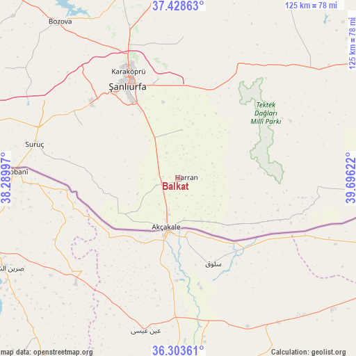
Balkat GPS coordinates[2]
36° 52' 5.484" North, 38° 59' 35.124" East
| Map corner | latitude | longitude |
|---|---|---|
| Upper-left | 37.42863°, | 38.28997° |
| Center: | 36.86819°, | 38.99309° |
| Lower-right: | 36.30361°, | 39.69622° |
| Map W x H: | 125.1×125.1 km | = 77.7×77.7mi |
| max Lat: | 42.02683° ⇑91.3% North |
| Balkat: | 36.86819° |
| min Lat: | ⇓8.7% South 35.9025° |
| min Long | Balkat | max Long |
| 25.90902° | 38.99309° | 44.60099° |
| W 67.4%⇐ | ⇒32.6% E |
Elevation
Elevation of Balkat is 371 m = 1217 ft, and this is 346.4 m = 1136 ft below average elevation for this country.
| Max E: |
2682 m = 8799 ft | 67.3% |
| Avg. | 717.4 m = 2354 ft | |
| Balkat | 371 m = 1217 ft | |
Min E: |
0 m = 0 ft | 32.7% |
See also: Turkey elevation on elevation.city.
Geographical zone
Balkat is located in North temperate zone (between Tropic of Cancer and the Arctic Circle). Distance of this Northern Tropic circle is 1493.4 km =928 mi to South.| Distance of | km | miles | from Balkat |
|---|---|---|---|
| North Pole | 5907.7 | 3670.9 | to North |
| Arctic Circle | 3301.8 | 2051.6 | to North |
| Tropic Cancer | 1493.4 | 928 | to South |
| Equator | 4099.4 | 2547.2 | to South |


Nearby cities:
15 places around Balkat: (largest is in red/bold)
• Aşağı Beğdeş
8.9 km =5.5 mi,  227°
227°
• Bolatlar
12 km =7.5 mi,  200°
200°
• Eskiharran
9.2 km =5.7 mi,  40°
40°
• Hacıekber
7.1 km =4.4 mi,  215°
215°
• Haktanır
11.4 km =7.1 mi,  262°
262°
• Harran
3.5 km =2.2 mi,  104°
104°
• Karatepe
10.6 km =6.6 mi,  288°
288°
• Keçikıran
10.9 km =6.8 mi,  356°
356°
• Küplüce
6.7 km =4.2 mi,  157°
157°
• Minare
7 km =4.3 mi,  8°
8°
• Ozanlar
12 km =7.5 mi,  315°
315°
• Parapara
9.8 km =6.1 mi,  334°
334°
• Sugeldi
7.5 km =4.7 mi,  143°
143°
• Tahılalan
2.4 km =1.5 mi, 229°
• Yukarı Beğdeş
8.2 km =5.1 mi,  252°
252°
Sources, notices
• [Note1] Compared only with cities in Turkey existing in our database
• [Src1] Map data: © OpenStreetMap contributors (CC-BY-SA)
• [Src2] Other city data from geonames.org with taken over terms of usage.
• [Src3] Geographical zone / Annual Mean Temperature by Robert A. Rohde @ Wikipedia
