Tahılalan geodata
Tahılalan (Şanlıurfa) is a populated place; located in Turkey in Europe/Istanbul (GMT+3) time zone. With population of 745 people, there are 1184 cities with bigger population in this country. Compared to other cities in Turkey, 91.8% of cities are located further ↑North; 67.2% of cities are located further ←West and 67.7% of cities have higher elevation than Tahılalan. Note1


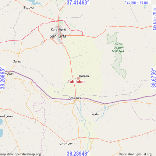
Tahılalan GPS coordinates[2]
36° 51' 14.904" North, 38° 58' 21.972" East
| Map corner | latitude | longitude |
|---|---|---|
| Upper-left | 37.41468°, | 38.26965° |
| Center: | 36.85414°, | 38.97277° |
| Lower-right: | 36.28946°, | 39.6759° |
| Map W x H: | 125.1×125.1 km | = 77.7×77.7mi |
| max Lat: | 42.02683° ⇑91.8% North |
| Tahılalan: | 36.85414° |
| min Lat: | ⇓8.2% South 35.9025° |
| min Long | Tahılalan | max Long |
| 25.90902° | 38.97277° | 44.60099° |
| W 67.2%⇐ | ⇒32.8% E |
Elevation
Elevation of Tahılalan is 362 m = 1188 ft, and this is 355.4 m = 1166 ft below average elevation for this country.
| Max E: |
2682 m = 8799 ft | 67.7% |
| Avg. | 717.4 m = 2354 ft | |
| Tahılalan | 362 m = 1188 ft | |
Min E: |
0 m = 0 ft | 32.3% |
See also: Turkey elevation on elevation.city.
Geographical zone
Tahılalan is located in North temperate zone (between Tropic of Cancer and the Arctic Circle). Distance of this Northern Tropic circle is 1491.9 km =927 mi to South.| Distance of | km | miles | from Tahılalan |
|---|---|---|---|
| North Pole | 5909.3 | 3671.9 | to North |
| Arctic Circle | 3303.4 | 2052.6 | to North |
| Tropic Cancer | 1491.9 | 927 | to South |
| Equator | 4097.8 | 2546.3 | to South |


Nearby cities:
15 places around Tahılalan: (largest is in red/bold)
• Aşağı Beğdeş
6.5 km =4 mi,  227°
227°
• Balkat
2.4 km =1.5 mi,  49°
49°
• Bolatlar
9.9 km =6.2 mi,  193°
193°
• Dorumali
12 km =7.5 mi,  242°
242°
• Eskiharran
11.5 km =7.1 mi,  42°
42°
• Hacıekber
4.9 km =3 mi,  208°
208°
• Haktanır
9.5 km =5.9 mi,  270°
270°
• Harran
5.3 km =3.3 mi,  82°
82°
• Karatepe
9.6 km =6 mi,  300°
300°
• Küplüce
6.4 km =4 mi,  136°
136°
• Minare
9 km =5.6 mi,  18°
18°
• Ozanlar
12.1 km =7.5 mi,  326°
326°
• Parapara
10.6 km =6.6 mi,  346°
346°
• Sugeldi
7.7 km =4.8 mi,  125°
125°
• Yukarı Beğdeş
6.1 km =3.8 mi,  261°
261°
Sources, notices
• [Note1] Compared only with cities in Turkey existing in our database
• [Src1] Map data: © OpenStreetMap contributors (CC-BY-SA)
• [Src2] Other city data from geonames.org with taken over terms of usage.
• [Src3] Geographical zone / Annual Mean Temperature by Robert A. Rohde @ Wikipedia
