Harran geodata
Harran (Şanlıurfa) is a seat of a second-order administrative division; located in Turkey in Europe/Istanbul (GMT+3) time zone. With population of 13,640 people, there are 415 cities with bigger population in this country. Compared to other cities in Turkey, 91.7% of cities are located further ↑North; 67.9% of cities are located further ←West and 67.4% of cities have higher elevation than Harran. Note1


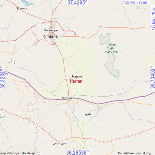
Harran GPS coordinates[2]
36° 51' 36" North, 39° 1' 53.004" East
| Map corner | latitude | longitude |
|---|---|---|
| Upper-left | 37.4205°, | 38.32827° |
| Center: | 36.86°, | 39.03139° |
| Lower-right: | 36.29536°, | 39.73452° |
| Map W x H: | 125.1×125.1 km | = 77.7×77.7mi |
| max Lat: | 42.02683° ⇑91.7% North |
| Harran: | 36.86° |
| min Lat: | ⇓8.3% South 35.9025° |
| min Long | Harran | max Long |
| 25.90902° | 39.03139° | 44.60099° |
| W 67.9%⇐ | ⇒32.1% E |
Elevation
Elevation of Harran is 369 m = 1211 ft, and this is 348.4 m = 1143 ft below average elevation for this country.
| Max E: |
2682 m = 8799 ft | 67.4% |
| Avg. | 717.4 m = 2354 ft | |
| Harran | 369 m = 1211 ft | |
Min E: |
0 m = 0 ft | 32.6% |
See also: Turkey elevation on elevation.city.
Geographical zone
Harran is located in North temperate zone (between Tropic of Cancer and the Arctic Circle). Distance of this Northern Tropic circle is 1492.5 km =927.4 mi to South.| Distance of | km | miles | from Harran |
|---|---|---|---|
| North Pole | 5908.6 | 3671.4 | to North |
| Arctic Circle | 3302.7 | 2052.2 | to North |
| Tropic Cancer | 1492.5 | 927.4 | to South |
| Equator | 4098.4 | 2546.6 | to South |


Nearby cities:
15 places around Harran: (largest is in red/bold)
• Aşağı Beğdeş
11.2 km =7 mi,  243°
243°
• Balkat
3.5 km =2.2 mi,  284°
284°
• Bolatlar
12.8 km =8 mi,  216°
216°
• Eskiharran
8.3 km =5.2 mi,  17°
17°
• Hacıekber
9 km =5.6 mi, 236°
• Keçikıran
12.5 km =7.8 mi,  340°
340°
• Küplüce
5.4 km =3.4 mi,  189°
189°
• Minare
8.2 km =5.1 mi, 343°
• Parapara
12.3 km =7.6 mi,  321°
321°
• Seksenören
13.1 km =8.1 mi, 17°
• Selalmaz
10.6 km =6.6 mi,  120°
120°
• Sugeldi
5.3 km =3.3 mi,  168°
168°
• Tahılalan
5.3 km =3.3 mi,  262°
262°
• Uluağaç
9.7 km =6 mi,  100°
100°
• Yukarı Beğdeş
11.4 km =7.1 mi, 262°
Sources, notices
• [Note1] Compared only with cities in Turkey existing in our database
• [Src1] Map data: © OpenStreetMap contributors (CC-BY-SA)
• [Src2] Other city data from geonames.org with taken over terms of usage.
• [Src3] Geographical zone / Annual Mean Temperature by Robert A. Rohde @ Wikipedia
