Bolatlar geodata
Bolatlar (Şanlıurfa) is a populated place; located in Turkey in Europe/Istanbul (GMT+3) time zone. With population of 882 people, there are 1122 cities with bigger population in this country. Compared to other cities in Turkey, 93.8% of cities are located further ↑North; 67% of cities are located further ←West and 67.7% of cities have higher elevation than Bolatlar. Note1


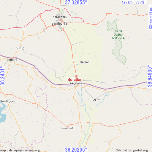
Bolatlar GPS coordinates[2]
36° 46' 2.532" North, 38° 56' 46.392" East
| Map corner | latitude | longitude |
|---|---|---|
| Upper-left | 37.32855°, | 38.2431° |
| Center: | 36.76737°, | 38.94622° |
| Lower-right: | 36.20205°, | 39.64935° |
| Map W x H: | 125.3×125.3 km | = 77.9×77.9mi |
| max Lat: | 42.02683° ⇑93.8% North |
| Bolatlar: | 36.76737° |
| min Lat: | ⇓6.2% South 35.9025° |
| min Long | Bolatlar | max Long |
| 25.90902° | 38.94622° | 44.60099° |
| W 67%⇐ | ⇒33% E |
Elevation
Elevation of Bolatlar is 362 m = 1188 ft, and this is 355.4 m = 1166 ft below average elevation for this country.
| Max E: |
2682 m = 8799 ft | 67.7% |
| Avg. | 717.4 m = 2354 ft | |
| Bolatlar | 362 m = 1188 ft | |
Min E: |
0 m = 0 ft | 32.3% |
See also: Turkey elevation on elevation.city.
Geographical zone
Bolatlar is located in North temperate zone (between Tropic of Cancer and the Arctic Circle). Distance of this Northern Tropic circle is 1482.2 km =921 mi to South.| Distance of | km | miles | from Bolatlar |
|---|---|---|---|
| North Pole | 5918.9 | 3677.8 | to North |
| Arctic Circle | 3313 | 2058.6 | to North |
| Tropic Cancer | 1482.2 | 921 | to South |
| Equator | 4088.1 | 2540.2 | to South |


Nearby cities:
15 places around Bolatlar: (largest is in red/bold)
• Akçakale
6.3 km =3.9 mi,  178°
178°
• Aşağı Beğdeş
5.8 km =3.6 mi,  335°
335°
• Balkat
12 km =7.5 mi,  20°
20°
• Dorumali
9.3 km =5.8 mi,  296°
296°
• Gyundash
12.6 km =7.8 mi,  252°
252°
• Güneren
13.2 km =8.2 mi,  106°
106°
• Hacıekber
5.4 km =3.4 mi,  0°
0°
• Haktanır
12.1 km =7.5 mi,  323°
323°
• Harran
12.8 km =8 mi,  36°
36°
• Karatepe
15.7 km =9.8 mi, 338°
• Küplüce
8.4 km =5.2 mi,  53°
53°
• Sugeldi
10.1 km =6.3 mi,  59°
59°
• Tahılalan
9.9 km =6.2 mi,  13°
13°
• Yukarı Beğdeş
9.5 km =5.9 mi, 337°
• Öncül
9.6 km =6 mi,  129°
129°
Sources, notices
• [Note1] Compared only with cities in Turkey existing in our database
• [Src1] Map data: © OpenStreetMap contributors (CC-BY-SA)
• [Src2] Other city data from geonames.org with taken over terms of usage.
• [Src3] Geographical zone / Annual Mean Temperature by Robert A. Rohde @ Wikipedia
