Balıkesir geodata
Balıkesir is a seat of a first-order administrative division; located in Turkey in Europe/Istanbul (GMT+3) time zone. With population of 238,151 people, there are 44 cities with bigger population in this country. Compared to other cities in Turkey, 63.7% of cities are located further ↓South; 90.9% of cities are located further →East and 77.9% of cities have higher elevation than Balıkesir. Note1


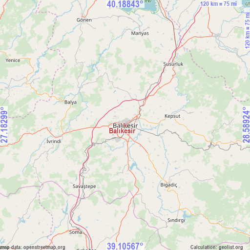
Balıkesir GPS coordinates[2]
39° 38' 57.012" North, 27° 53' 9.996" East
| Map corner | latitude | longitude |
|---|---|---|
| Upper-left | 40.18843°, | 27.18299° |
| Center: | 39.64917°, | 27.88611° |
| Lower-right: | 39.10567°, | 28.58924° |
| Map W x H: | 120.4×120.4 km | = 74.8×74.8mi |
| max Lat: | 42.02683° ⇑36.3% North |
| Balıkesir: | 39.64917° |
| min Lat: | ⇓63.7% South 35.9025° |
| min Long | Balıkesir | max Long |
| 25.90902° | 27.88611° | 44.60099° |
| W 9.1%⇐ | ⇒90.9% E |
Elevation
Elevation of Balıkesir is 139 m = 456 ft, and this is 578.4 m = 1898 ft below average elevation for this country.
| Max E: |
2682 m = 8799 ft | 77.9% |
| Avg. | 717.4 m = 2354 ft | |
| Balıkesir | 139 m = 456 ft | |
Min E: |
0 m = 0 ft | 22.1% |
See also: Balıkesir elevation on elevation.city.
Geographical zone
Balıkesir is located in North temperate zone (between Tropic of Cancer and the Arctic Circle). Distance of this Northern Tropic circle is 1802.7 km =1120.1 mi to South.| Distance of | km | miles | from Balıkesir |
|---|---|---|---|
| North Pole | 5598.5 | 3478.7 | to North |
| Arctic Circle | 2992.6 | 1859.5 | to North |
| Tropic Cancer | 1802.7 | 1120.1 | to South |
| Equator | 4408.6 | 2739.4 | to South |


Nearby cities:
15 places around Balıkesir: (largest is in red/bold)
• Balya
28.5 km =17.7 mi,  292°
292°
• Bigadiç
35.4 km =22 mi,  143°
143°
• Danişment
32.7 km =20.3 mi,  318°
318°
• Durak
33.6 km =20.9 mi,  79°
79°
• Ergama
21.9 km =13.6 mi,  263°
263°
• Ertuğrul
17.4 km =10.8 mi,  242°
242°
• Ilıca
26.9 km =16.7 mi,  339°
339°
• Kepsut
23.2 km =14.4 mi, 79°
• Konakpınar
24.3 km =15.1 mi,  190°
190°
• Savaştepe
35.6 km =22.1 mi,  213°
213°
• Yeniköy
17.5 km =10.9 mi,  34°
34°
• Çağış
18.1 km =11.2 mi, 143°
• Ömerköy
25.4 km =15.8 mi,  37°
37°
• İvrindi
35 km =21.7 mi, 258°
• Şamlı
18.4 km =11.4 mi,  349°
349°
Sources, notices
• [Note1] Compared only with cities in Turkey existing in our database
• [Src1] Map data: © OpenStreetMap contributors (CC-BY-SA)
• [Src2] Other city data from geonames.org with taken over terms of usage.
• [Src3] Geographical zone / Annual Mean Temperature by Robert A. Rohde @ Wikipedia
