Balya geodata
Balya (Balıkesir) is a seat of a second-order administrative division; located in Turkey in Europe/Istanbul (GMT+3) time zone. With population of 1,765 people, there are 982 cities with bigger population in this country. Compared to other cities in Turkey, 64.8% of cities are located further ↓South; 93% of cities are located further →East and 72.7% of cities have higher elevation than Balya. Note1


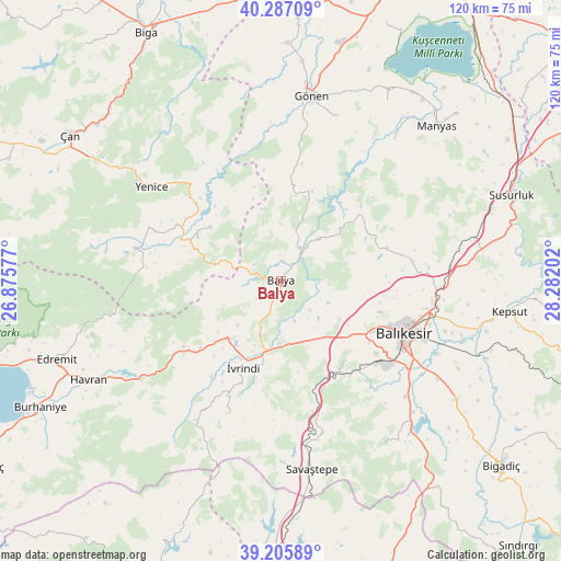
Balya GPS coordinates[2]
39° 44' 54.996" North, 27° 34' 44.004" East
| Map corner | latitude | longitude |
|---|---|---|
| Upper-left | 40.28709°, | 26.87577° |
| Center: | 39.74861°, | 27.57889° |
| Lower-right: | 39.20589°, | 28.28202° |
| Map W x H: | 120.2×120.2 km | = 74.7×74.7mi |
| max Lat: | 42.02683° ⇑35.2% North |
| Balya: | 39.74861° |
| min Lat: | ⇓64.8% South 35.9025° |
| min Long | Balya | max Long |
| 25.90902° | 27.57889° | 44.60099° |
| W 7%⇐ | ⇒93% E |
Elevation
Elevation of Balya is 221 m = 725 ft, and this is 496.4 m = 1629 ft below average elevation for this country.
| Max E: |
2682 m = 8799 ft | 72.7% |
| Avg. | 717.4 m = 2354 ft | |
| Balya | 221 m = 725 ft | |
Min E: |
0 m = 0 ft | 27.3% |
See also: Turkey elevation on elevation.city.
Geographical zone
Balya is located in North temperate zone (between Tropic of Cancer and the Arctic Circle). Distance of this Northern Tropic circle is 1813.7 km =1127 mi to South.| Distance of | km | miles | from Balya |
|---|---|---|---|
| North Pole | 5587.4 | 3471.8 | to North |
| Arctic Circle | 2981.5 | 1852.6 | to North |
| Tropic Cancer | 1813.7 | 1127 | to South |
| Equator | 4419.6 | 2746.2 | to South |


Nearby cities:
15 places around Balya: (largest is in red/bold)
• Balıkesir
28.5 km =17.7 mi,  112°
112°
• Danişment
14.2 km =8.8 mi,  19°
19°
• Ergama
14.2 km =8.8 mi,  161°
161°
• Ertuğrul
22.1 km =13.7 mi,  150°
150°
• Hamdibey
30.4 km =18.9 mi,  291°
291°
• Ilıca
22 km =13.7 mi,  50°
50°
• Kalkım
31.9 km =19.8 mi,  282°
282°
• Kayapa
30.7 km =19.1 mi,  201°
201°
• Korucu
36 km =22.4 mi,  210°
210°
• Pazarköy
19 km =11.8 mi,  307°
307°
• Tütüncü
37.4 km =23.2 mi, 18°
• Yenice
34.1 km =21.2 mi, 306°
• Yeniköy
36.4 km =22.6 mi,  84°
84°
• İvrindi
20 km =12.4 mi, 203°
• Şamlı
23.8 km =14.8 mi,  72°
72°
Sources, notices
• [Note1] Compared only with cities in Turkey existing in our database
• [Src1] Map data: © OpenStreetMap contributors (CC-BY-SA)
• [Src2] Other city data from geonames.org with taken over terms of usage.
• [Src3] Geographical zone / Annual Mean Temperature by Robert A. Rohde @ Wikipedia
