İvrindi geodata
İvrindi (Balıkesir) is a seat of a second-order administrative division; located in Turkey in Europe/Istanbul (GMT+3) time zone. With population of 6,119 people, there are 651 cities with bigger population in this country. Compared to other cities in Turkey, 62.6% of cities are located further ↓South; 93.6% of cities are located further →East and 71.1% of cities have higher elevation than İvrindi. Note1


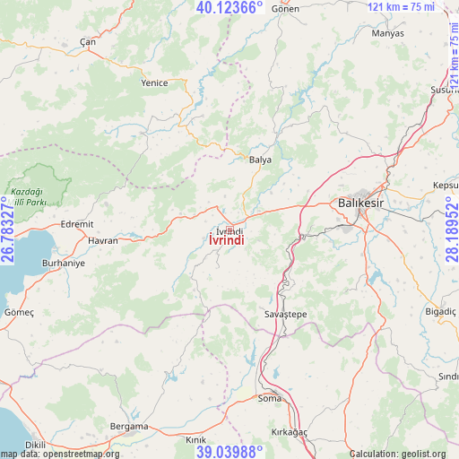
İvrindi GPS coordinates[2]
39° 35' 2.004" North, 27° 29' 11.004" East
| Map corner | latitude | longitude |
|---|---|---|
| Upper-left | 40.12366°, | 26.78327° |
| Center: | 39.58389°, | 27.48639° |
| Lower-right: | 39.03988°, | 28.18952° |
| Map W x H: | 120.5×120.5 km | = 74.9×74.9mi |
| max Lat: | 42.02683° ⇑37.4% North |
| İvrindi: | 39.58389° |
| min Lat: | ⇓62.6% South 35.9025° |
| min Long | İvrindi | max Long |
| 25.90902° | 27.48639° | 44.60099° |
| W 6.4%⇐ | ⇒93.6% E |
Elevation
Elevation of İvrindi is 259 m = 850 ft, and this is 458.4 m = 1504 ft below average elevation for this country.
| Max E: |
2682 m = 8799 ft | 71.1% |
| Avg. | 717.4 m = 2354 ft | |
| İvrindi | 259 m = 850 ft | |
Min E: |
0 m = 0 ft | 28.9% |
See also: Turkey elevation on elevation.city.
Geographical zone
İvrindi is located in North temperate zone (between Tropic of Cancer and the Arctic Circle). Distance of this Northern Tropic circle is 1795.4 km =1115.6 mi to South.| Distance of | km | miles | from İvrindi |
|---|---|---|---|
| North Pole | 5605.7 | 3483.2 | to North |
| Arctic Circle | 2999.9 | 1864.1 | to North |
| Tropic Cancer | 1795.4 | 1115.6 | to South |
| Equator | 4401.3 | 2734.8 | to South |


Nearby cities:
15 places around İvrindi: (largest is in red/bold)
• Balya
20 km =12.4 mi,  23°
23°
• Balıkesir
35 km =21.7 mi,  78°
78°
• Danişment
34.1 km =21.2 mi, 21°
• Ergama
13.3 km =8.3 mi,  68°
68°
• Ertuğrul
18.9 km =11.7 mi,  92°
92°
• Hamdibey
35.9 km =22.3 mi,  325°
325°
• Havran
33.4 km =20.8 mi,  265°
265°
• Kalkım
34.4 km =21.4 mi,  317°
317°
• Kayapa
10.7 km =6.6 mi,  199°
199°
• Konakpınar
34.3 km =21.3 mi,  119°
119°
• Korucu
16.4 km =10.2 mi,  219°
219°
• Pazarköy
30.8 km =19.1 mi,  346°
346°
• Sarıbeyler
22.1 km =13.7 mi,  159°
159°
• Savaştepe
26.6 km =16.5 mi,  146°
146°
• Turanlı
36.9 km =22.9 mi, 202°
Sources, notices
• [Note1] Compared only with cities in Turkey existing in our database
• [Src1] Map data: © OpenStreetMap contributors (CC-BY-SA)
• [Src2] Other city data from geonames.org with taken over terms of usage.
• [Src3] Geographical zone / Annual Mean Temperature by Robert A. Rohde @ Wikipedia
