Ayvalık geodata
Ayvalık (Balıkesir) is a seat of a second-order administrative division; located in Turkey in Europe/Istanbul (GMT+3) time zone. With population of 70,002 people, there are 135 cities with bigger population in this country. Compared to other cities in Turkey, 59.2% of cities are located further ↓South; 98.4% of cities are located further →East and 86.5% of cities have higher elevation than Ayvalık. Note1


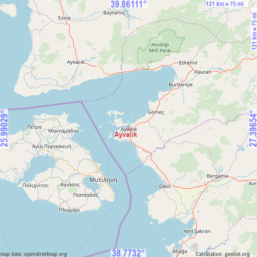
Ayvalık GPS coordinates[2]
39° 19' 9.372" North, 26° 41' 36.276" East
| Map corner | latitude | longitude |
|---|---|---|
| Upper-left | 39.86111°, | 25.99029° |
| Center: | 39.31927°, | 26.69341° |
| Lower-right: | 38.7732°, | 27.39654° |
| Map W x H: | 121×121 km | = 75.2×75.2mi |
| max Lat: | 42.02683° ⇑40.8% North |
| Ayvalık: | 39.31927° |
| min Lat: | ⇓59.2% South 35.9025° |
| min Long | Ayvalık | max Long |
| 25.90902° | 26.69341° | 44.60099° |
| W 1.6%⇐ | ⇒98.4% E |
Elevation
Elevation of Ayvalık is 63 m = 207 ft, and this is 654.4 m = 2147 ft below average elevation for this country.
| Max E: |
2682 m = 8799 ft | 86.5% |
| Avg. | 717.4 m = 2354 ft | |
| Ayvalık | 63 m = 207 ft | |
Min E: |
0 m = 0 ft | 13.5% |
See also: Ayvalık elevation on elevation.city.
Geographical zone
Ayvalık is located in North temperate zone (between Tropic of Cancer and the Arctic Circle). Distance of this Northern Tropic circle is 1766 km =1097.3 mi to South.| Distance of | km | miles | from Ayvalık |
|---|---|---|---|
| North Pole | 5635.2 | 3501.5 | to North |
| Arctic Circle | 3029.3 | 1882.3 | to North |
| Tropic Cancer | 1766 | 1097.3 | to South |
| Equator | 4371.9 | 2716.6 | to South |


Nearby cities:
15 places around Ayvalık: (largest is in red/bold)
• Altınoluk
29.2 km =18.1 mi,  7°
7°
• Altınova
14.1 km =8.8 mi,  143°
143°
• Ayvacık
40 km =24.9 mi,  321°
321°
• Behram
36.5 km =22.7 mi,  302°
302°
• Bergama
47.4 km =29.5 mi,  117°
117°
• Burhaniye
31.3 km =19.4 mi,  49°
49°
• Dikili
32.4 km =20.1 mi,  148°
148°
• Edremit
41.9 km =26 mi,  42°
42°
• Evciler
51.2 km =31.8 mi, 7°
• Gömeç
15 km =9.3 mi,  58°
58°
• Havran
43.8 km =27.2 mi, 52°
• Kozak
35 km =21.7 mi,  102°
102°
• Küçükkuyu
26.6 km =16.5 mi,  343°
343°
• Zeytindağ
51 km =31.7 mi, 140°
• Çandarlı
47.5 km =29.5 mi, 154°
Sources, notices
• [Note1] Compared only with cities in Turkey existing in our database
• [Src1] Map data: © OpenStreetMap contributors (CC-BY-SA)
• [Src2] Other city data from geonames.org with taken over terms of usage.
• [Src3] Geographical zone / Annual Mean Temperature by Robert A. Rohde @ Wikipedia
