Altınova geodata
Altınova (Balıkesir) is a seat of a third-order administrative division; located in Turkey in Europe/Istanbul (GMT+3) time zone. In our database, there are 1323 cities with bigger population. Compared to other cities in Turkey, 57.6% of cities are located further ↓South; 98% of cities are located further →East and 95.5% of cities have higher elevation than Altınova. Note1


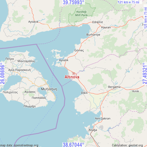
Altınova GPS coordinates[2]
39° 13' 2.28" North, 26° 47' 24.288" East
| Map corner | latitude | longitude |
|---|---|---|
| Upper-left | 39.75993°, | 26.08696° |
| Center: | 39.2173°, | 26.79008° |
| Lower-right: | 38.67044°, | 27.49321° |
| Map W x H: | 121.1×121.1 km | = 75.2×75.2mi |
| max Lat: | 42.02683° ⇑42.4% North |
| Altınova: | 39.2173° |
| min Lat: | ⇓57.6% South 35.9025° |
| min Long | Altınova | max Long |
| 25.90902° | 26.79008° | 44.60099° |
| W 2%⇐ | ⇒98% E |
Elevation
Elevation of Altınova is 15 m = 49 ft, and this is 702.4 m = 2304 ft below average elevation for this country.
| Max E: |
2682 m = 8799 ft | 95.5% |
| Avg. | 717.4 m = 2354 ft | |
| Altınova | 15 m = 49 ft | |
Min E: |
0 m = 0 ft | 4.5% |
See also: Turkey elevation on elevation.city.
Geographical zone
Altınova is located in North temperate zone (between Tropic of Cancer and the Arctic Circle). Distance of this Northern Tropic circle is 1754.6 km =1090.3 mi to South.| Distance of | km | miles | from Altınova |
|---|---|---|---|
| North Pole | 5646.5 | 3508.6 | to North |
| Arctic Circle | 3040.6 | 1889.3 | to North |
| Tropic Cancer | 1754.6 | 1090.3 | to South |
| Equator | 4360.6 | 2709.6 | to South |


Nearby cities:
15 places around Altınova: (largest is in red/bold)
• Altınoluk
40.5 km =25.2 mi,  353°
353°
• Ayvalık
14.1 km =8.8 mi,  323°
323°
• Bergama
35.3 km =21.9 mi,  107°
107°
• Burhaniye
35.2 km =21.9 mi,  26°
26°
• Dikili
18.4 km =11.4 mi,  152°
152°
• Edremit
46.7 km =29 mi, 25°
• Gömeç
19.7 km =12.2 mi,  12°
12°
• Havran
46.3 km =28.8 mi, 34°
• Kozak
26.1 km =16.2 mi,  81°
81°
• Küçükkuyu
40.1 km =24.9 mi,  336°
336°
• Turanlı
46.5 km =28.9 mi, 81°
• Yenişakran
43.9 km =27.3 mi, 146°
• Yuntdağ
48.4 km =30.1 mi,  130°
130°
• Zeytindağ
37 km =23 mi,  138°
138°
• Çandarlı
33.8 km =21 mi,  158°
158°
Sources, notices
• [Note1] Compared only with cities in Turkey existing in our database
• [Src1] Map data: © OpenStreetMap contributors (CC-BY-SA)
• [Src2] Other city data from geonames.org with taken over terms of usage.
• [Src3] Geographical zone / Annual Mean Temperature by Robert A. Rohde @ Wikipedia
