Behram geodata
Behram (Canakkale) is a populated place; located in Turkey in Europe/Istanbul (GMT+3) time zone. With population of 1,100 people, there are 1068 cities with bigger population in this country. Compared to other cities in Turkey, 61.2% of cities are located further ↓South; 99.7% of cities are located further →East and 77.1% of cities have higher elevation than Behram. Note1


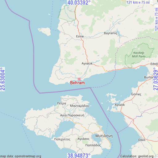
Behram GPS coordinates[2]
39° 29' 36.384" North, 26° 19' 59.376" East
| Map corner | latitude | longitude |
|---|---|---|
| Upper-left | 40.03392°, | 25.63004° |
| Center: | 39.49344°, | 26.33316° |
| Lower-right: | 38.94873°, | 27.03629° |
| Map W x H: | 120.7×120.7 km | = 75×75mi |
| max Lat: | 42.02683° ⇑38.8% North |
| Behram: | 39.49344° |
| min Lat: | ⇓61.2% South 35.9025° |
| min Long | Behram | max Long |
| 25.90902° | 26.33316° | 44.60099° |
| W 0.3%⇐ | ⇒99.7% E |
Elevation
Elevation of Behram is 150 m = 492 ft, and this is 567.4 m = 1862 ft below average elevation for this country.
| Max E: |
2682 m = 8799 ft | 77.1% |
| Avg. | 717.4 m = 2354 ft | |
| Behram | 150 m = 492 ft | |
Min E: |
0 m = 0 ft | 22.9% |
See also: Turkey elevation on elevation.city.
Geographical zone
Behram is located in North temperate zone (between Tropic of Cancer and the Arctic Circle). Distance of this Northern Tropic circle is 1785.3 km =1109.3 mi to South.| Distance of | km | miles | from Behram |
|---|---|---|---|
| North Pole | 5615.8 | 3489.5 | to North |
| Arctic Circle | 3009.9 | 1870.3 | to North |
| Tropic Cancer | 1785.3 | 1109.3 | to South |
| Equator | 4391.3 | 2728.6 | to South |


Nearby cities:
15 places around Behram: (largest is in red/bold)
• Altınoluk
35.9 km =22.3 mi,  74°
74°
• Altınova
49.9 km =31 mi,  128°
128°
• Ayvacık
13.5 km =8.4 mi,  27°
27°
• Ayvalık
36.5 km =22.7 mi,  122°
122°
• Bayramiç
42.3 km =26.3 mi, 34°
• Bozcaada
44.2 km =27.5 mi,  329°
329°
• Burhaniye
54.9 km =34.1 mi,  89°
89°
• Evciler
48.9 km =30.4 mi,  50°
50°
• Ezine
32.5 km =20.2 mi,  1°
1°
• Geyikli
36.2 km =22.5 mi,  342°
342°
• Gömeç
45.1 km =28 mi,  104°
104°
• Gülpınar
18.8 km =11.7 mi,  283°
283°
• Küçükkuyu
24.1 km =15 mi,  75°
75°
• Yiğitler
47.9 km =29.8 mi, 29°
• İntepe
57.8 km =35.9 mi,  359°
359°
Sources, notices
• [Note1] Compared only with cities in Turkey existing in our database
• [Src1] Map data: © OpenStreetMap contributors (CC-BY-SA)
• [Src2] Other city data from geonames.org with taken over terms of usage.
• [Src3] Geographical zone / Annual Mean Temperature by Robert A. Rohde @ Wikipedia
