Bergama geodata
Bergama (İzmir) is a populated place; located in Turkey in Europe/Istanbul (GMT+3) time zone. With population of 57,200 people, there are 151 cities with bigger population in this country. Compared to other cities in Turkey, 56.3% of cities are located further ↓South; 95.7% of cities are located further →East and 85.3% of cities have higher elevation than Bergama. Note1


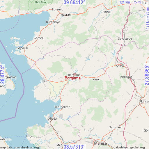
Bergama GPS coordinates[2]
39° 7' 14.664" North, 27° 10' 49.872" East
| Map corner | latitude | longitude |
|---|---|---|
| Upper-left | 39.66412°, | 26.4774° |
| Center: | 39.12074°, | 27.18052° |
| Lower-right: | 38.57313°, | 27.88365° |
| Map W x H: | 121.3×121.3 km | = 75.4×75.4mi |
| max Lat: | 42.02683° ⇑43.7% North |
| Bergama: | 39.12074° |
| min Lat: | ⇓56.3% South 35.9025° |
| min Long | Bergama | max Long |
| 25.90902° | 27.18052° | 44.60099° |
| W 4.3%⇐ | ⇒95.7% E |
Elevation
Elevation of Bergama is 69 m = 226 ft, and this is 648.4 m = 2127 ft below average elevation for this country.
| Max E: |
2682 m = 8799 ft | 85.3% |
| Avg. | 717.4 m = 2354 ft | |
| Bergama | 69 m = 226 ft | |
Min E: |
0 m = 0 ft | 14.7% |
See also: Bergama elevation on elevation.city.
Geographical zone
Bergama is located in North temperate zone (between Tropic of Cancer and the Arctic Circle). Distance of this Northern Tropic circle is 1743.9 km =1083.6 mi to South.| Distance of | km | miles | from Bergama |
|---|---|---|---|
| North Pole | 5657.2 | 3515.2 | to North |
| Arctic Circle | 3051.4 | 1896.1 | to North |
| Tropic Cancer | 1743.9 | 1083.6 | to South |
| Equator | 4349.8 | 2702.8 | to South |


Nearby cities:
15 places around Bergama: (largest is in red/bold)
• Aliağa
40 km =24.9 mi,  206°
206°
• Altınova
35.3 km =21.9 mi,  287°
287°
• Dikili
25.7 km =16 mi,  257°
257°
• Gömeç
41.8 km =26 mi,  315°
315°
• Göçbeyli
22.4 km =13.9 mi,  59°
59°
• Korucu
42 km =26.1 mi,  22°
22°
• Kozak
16.5 km =10.3 mi,  331°
331°
• Kınık
17.9 km =11.1 mi,  102°
102°
• Osmancalı
40.3 km =25 mi,  171°
171°
• Soma
37.7 km =23.4 mi,  78°
78°
• Turanlı
21.3 km =13.2 mi,  35°
35°
• Yenişakran
27.8 km =17.3 mi,  200°
200°
• Yuntdağ
21.2 km =13.2 mi, 172°
• Zeytindağ
19.5 km =12.1 mi, 208°
• Çandarlı
29.7 km =18.5 mi,  225°
225°
In other languages:
- In Spanish: Pérgamo
- In France: Pergame
- In Italian: Pergamo
- In Russian: Пергам
- In Chinese: 別迦摩, 帕加马
Sources, notices
• [Note1] Compared only with cities in Turkey existing in our database
• [Src1] Map data: © OpenStreetMap contributors (CC-BY-SA)
• [Src2] Other city data from geonames.org with taken over terms of usage.
• [Src3] Geographical zone / Annual Mean Temperature by Robert A. Rohde @ Wikipedia
