Yuntdağ geodata
Yuntdağ (İzmir) is a seat of a third-order administrative division; located in Turkey in Europe/Istanbul (GMT+3) time zone. In our database, there are 1323 cities with bigger population. Compared to other cities in Turkey, 53.4% of cities are located further ↓South; 95.7% of cities are located further →East and 63.1% of cities have higher elevation than Yuntdağ. Note1


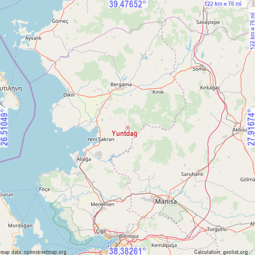
Yuntdağ GPS coordinates[2]
38° 55' 54.012" North, 27° 12' 48.996" East
| Map corner | latitude | longitude |
|---|---|---|
| Upper-left | 39.47652°, | 26.51049° |
| Center: | 38.93167°, | 27.21361° |
| Lower-right: | 38.38261°, | 27.91674° |
| Map W x H: | 121.6×121.6 km | = 75.6×75.6mi |
| max Lat: | 42.02683° ⇑46.6% North |
| Yuntdağ: | 38.93167° |
| min Lat: | ⇓53.4% South 35.9025° |
| min Long | Yuntdağ | max Long |
| 25.90902° | 27.21361° | 44.60099° |
| W 4.3%⇐ | ⇒95.7% E |
Elevation
Elevation of Yuntdağ is 450 m = 1476 ft, and this is 267.4 m = 877 ft below average elevation for this country.
| Max E: |
2682 m = 8799 ft | 63.1% |
| Avg. | 717.4 m = 2354 ft | |
| Yuntdağ | 450 m = 1476 ft | |
Min E: |
0 m = 0 ft | 36.9% |
See also: Turkey elevation on elevation.city.
Geographical zone
Yuntdağ is located in North temperate zone (between Tropic of Cancer and the Arctic Circle). Distance of this Northern Tropic circle is 1722.9 km =1070.6 mi to South.| Distance of | km | miles | from Yuntdağ |
|---|---|---|---|
| North Pole | 5678.3 | 3528.3 | to North |
| Arctic Circle | 3072.4 | 1909.1 | to North |
| Tropic Cancer | 1722.9 | 1070.6 | to South |
| Equator | 4328.8 | 2689.8 | to South |


Nearby cities:
15 places around Yuntdağ: (largest is in red/bold)
• Aliağa
25.5 km =15.8 mi,  234°
234°
• Bergama
21.2 km =13.2 mi,  352°
352°
• Dikili
32 km =19.9 mi,  299°
299°
• Emiralem
36.3 km =22.6 mi,  189°
189°
• Göçbeyli
36.3 km =22.6 mi,  26°
26°
• Kozak
37.1 km =23.1 mi,  343°
343°
• Kınık
22.7 km =14.1 mi,  40°
40°
• Menemen
38.1 km =23.7 mi,  199°
199°
• Muradiye
32.1 km =19.9 mi,  160°
160°
• Osmancalı
19.1 km =11.9 mi,  169°
169°
• Saruhanlı
37.7 km =23.4 mi,  125°
125°
• Yenişakran
13.7 km =8.5 mi,  248°
248°
• Zeytindağ
12.8 km =8 mi,  287°
287°
• Çandarlı
24.2 km =15 mi,  270°
270°
• Üçpınar
25.4 km =15.8 mi,  149°
149°
Sources, notices
• [Note1] Compared only with cities in Turkey existing in our database
• [Src1] Map data: © OpenStreetMap contributors (CC-BY-SA)
• [Src2] Other city data from geonames.org with taken over terms of usage.
• [Src3] Geographical zone / Annual Mean Temperature by Robert A. Rohde @ Wikipedia
