Kopuzlu geodata
Kopuzlu (Diyarbakır) is a populated place; located in Turkey in Europe/Istanbul (GMT+3) time zone. With population of 618 people, there are 1243 cities with bigger population in this country. Compared to other cities in Turkey, 62.9% of cities are located further ↑North; 80.8% of cities are located further ←West and 52.6% of cities have higher elevation than Kopuzlu. Note1


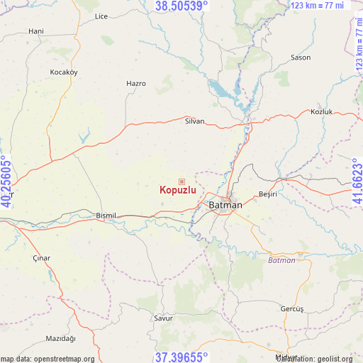
Kopuzlu GPS coordinates[2]
37° 57' 11.016" North, 40° 57' 33.012" East
| Map corner | latitude | longitude |
|---|---|---|
| Upper-left | 38.50539°, | 40.25605° |
| Center: | 37.95306°, | 40.95917° |
| Lower-right: | 37.39655°, | 41.6623° |
| Map W x H: | 123.3×123.3 km | = 76.6×76.6mi |
| max Lat: | 42.02683° ⇑62.9% North |
| Kopuzlu: | 37.95306° |
| min Lat: | ⇓37.1% South 35.9025° |
| min Long | Kopuzlu | max Long |
| 25.90902° | 40.95917° | 44.60099° |
| W 80.8%⇐ | ⇒19.2% E |
Elevation
Elevation of Kopuzlu is 641 m = 2103 ft, and this is 76.4 m = 251 ft below average elevation for this country.
| Max E: |
2682 m = 8799 ft | 52.6% |
| Avg. | 717.4 m = 2354 ft | |
| Kopuzlu | 641 m = 2103 ft | |
Min E: |
0 m = 0 ft | 47.4% |
See also: Turkey elevation on elevation.city.
Geographical zone
Kopuzlu is located in North temperate zone (between Tropic of Cancer and the Arctic Circle). Distance of this Northern Tropic circle is 1614.1 km =1003 mi to South.| Distance of | km | miles | from Kopuzlu |
|---|---|---|---|
| North Pole | 5787.1 | 3595.9 | to North |
| Arctic Circle | 3181.2 | 1976.7 | to North |
| Tropic Cancer | 1614.1 | 1003 | to South |
| Equator | 4220 | 2622.2 | to South |


Nearby cities:
15 places around Kopuzlu: (largest is in red/bold)
• Akbaş
9.1 km =5.7 mi,  73°
73°
• Akoba
8.5 km =5.3 mi,  97°
97°
• Akçayır
5 km =3.1 mi,  32°
32°
• Bademli
3 km =1.9 mi,  176°
176°
• Balpınar
12.7 km =7.9 mi,  138°
138°
• Batman
16.8 km =10.4 mi,  115°
115°
• Demiryol
17.2 km =10.7 mi, 103°
• Diktepe
9.7 km =6 mi,  112°
112°
• Güngeçti
6.7 km =4.2 mi,  215°
215°
• Karayün
18.9 km =11.7 mi,  134°
134°
• Oymataş
18 km =11.2 mi,  162°
162°
• Salat
13.9 km =8.6 mi,  207°
207°
• Sinanköy
10.6 km =6.6 mi, 163°
• Yeniköy
11.3 km =7 mi, 135°
• İkiztepe
12.9 km =8 mi, 121°
Sources, notices
• [Note1] Compared only with cities in Turkey existing in our database
• [Src1] Map data: © OpenStreetMap contributors (CC-BY-SA)
• [Src2] Other city data from geonames.org with taken over terms of usage.
• [Src3] Geographical zone / Annual Mean Temperature by Robert A. Rohde @ Wikipedia
