Çardaklı geodata
Çardaklı (Şırnak) is a populated place; located in Turkey in Europe/Istanbul (GMT+3) time zone. With population of 1,171 people, there are 1053 cities with bigger population in this country. Compared to other cities in Turkey, 82.3% of cities are located further ↑North; 94.7% of cities are located further ←West and 52.2% of cities have higher elevation than Çardaklı. Note1


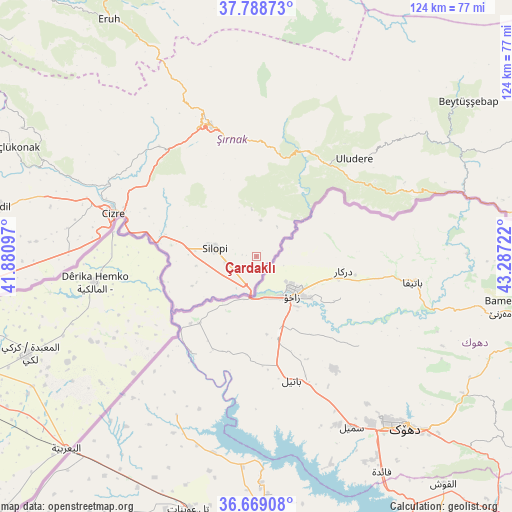
Çardaklı GPS coordinates[2]
37° 13' 51.528" North, 42° 35' 2.724" East
| Map corner | latitude | longitude |
|---|---|---|
| Upper-left | 37.78873°, | 41.88097° |
| Center: | 37.23098°, | 42.58409° |
| Lower-right: | 36.66908°, | 43.28722° |
| Map W x H: | 124.5×124.5 km | = 77.4×77.4mi |
| max Lat: | 42.02683° ⇑82.3% North |
| Çardaklı: | 37.23098° |
| min Lat: | ⇓17.7% South 35.9025° |
| min Long | Çardaklı | max Long |
| 25.90902° | 42.58409° | 44.60099° |
| W 94.7%⇐ | ⇒5.3% E |
Elevation
Elevation of Çardaklı is 649 m = 2129 ft, and this is 68.4 m = 224 ft below average elevation for this country.
| Max E: |
2682 m = 8799 ft | 52.2% |
| Avg. | 717.4 m = 2354 ft | |
| Çardaklı | 649 m = 2129 ft | |
Min E: |
0 m = 0 ft | 47.8% |
See also: Turkey elevation on elevation.city.
Geographical zone
Çardaklı is located in North temperate zone (between Tropic of Cancer and the Arctic Circle). Distance of this Northern Tropic circle is 1533.8 km =953.1 mi to South.| Distance of | km | miles | from Çardaklı |
|---|---|---|---|
| North Pole | 5867.4 | 3645.8 | to North |
| Arctic Circle | 3261.5 | 2026.6 | to North |
| Tropic Cancer | 1533.8 | 953.1 | to South |
| Equator | 4139.7 | 2572.3 | to South |


Nearby cities:
15 places around Çardaklı: (largest is in red/bold)
• Balveren
28.3 km =17.6 mi,  353°
353°
• Bağlıca
28.1 km =17.5 mi,  36°
36°
• Bisbin
12.1 km =7.5 mi, 353°
• Bostancı
23.3 km =14.5 mi,  255°
255°
• Buğdaylı
17.2 km =10.7 mi,  246°
246°
• Doruklu
22.2 km =13.8 mi,  277°
277°
• Girikbedro
15.5 km =9.6 mi, 248°
• Kavallı
14.7 km =9.1 mi, 261°
• Ortaköy
12.7 km =7.9 mi, 253°
• Razvaliny Ayinvan
22.8 km =14.2 mi, 283°
• Rubaikale
21.1 km =13.1 mi,  266°
266°
• Silopi
10.8 km =6.7 mi, 277°
• Yeniköy
14.8 km =9.2 mi,  287°
287°
• Çalışkan
9 km =5.6 mi,  34°
34°
• Şenoba
28.7 km =17.8 mi, 25°
Sources, notices
• [Note1] Compared only with cities in Turkey existing in our database
• [Src1] Map data: © OpenStreetMap contributors (CC-BY-SA)
• [Src2] Other city data from geonames.org with taken over terms of usage.
• [Src3] Geographical zone / Annual Mean Temperature by Robert A. Rohde @ Wikipedia
