Doğanköy geodata
Doğanköy (Hatay) is a populated place; located in Turkey in Europe/Istanbul (GMT+3) time zone. With population of 655 people, there are 1223 cities with bigger population in this country. Compared to other cities in Turkey, 98.3% of cities are located further ↑North; 51.1% of cities are located further ←West and 73.5% of cities have higher elevation than Doğanköy. Note1


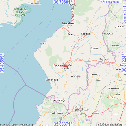
Doğanköy GPS coordinates[2]
36° 13' 58.512" North, 36° 6' 32.796" East
| Map corner | latitude | longitude |
|---|---|---|
| Upper-left | 36.79801°, | 35.40599° |
| Center: | 36.23292°, | 36.10911° |
| Lower-right: | 35.66371°, | 36.81224° |
| Map W x H: | 126.1×126.1 km | = 78.4×78.4mi |
| max Lat: | 42.02683° ⇑98.3% North |
| Doğanköy: | 36.23292° |
| min Lat: | ⇓1.7% South 35.9025° |
| min Long | Doğanköy | max Long |
| 25.90902° | 36.10911° | 44.60099° |
| W 51.1%⇐ | ⇒48.9% E |
Elevation
Elevation of Doğanköy is 201 m = 659 ft, and this is 516.4 m = 1694 ft below average elevation for this country.
| Max E: |
2682 m = 8799 ft | 73.5% |
| Avg. | 717.4 m = 2354 ft | |
| Doğanköy | 201 m = 659 ft | |
Min E: |
0 m = 0 ft | 26.5% |
See also: Turkey elevation on elevation.city.
Geographical zone
Doğanköy is located in North temperate zone (between Tropic of Cancer and the Arctic Circle). Distance of this Northern Tropic circle is 1422.8 km =884.1 mi to South.| Distance of | km | miles | from Doğanköy |
|---|---|---|---|
| North Pole | 5978.3 | 3714.7 | to North |
| Arctic Circle | 3372.5 | 2095.6 | to North |
| Tropic Cancer | 1422.8 | 884.1 | to South |
| Equator | 4028.7 | 2503.3 | to South |


Nearby cities:
15 places around Doğanköy: (largest is in red/bold)
• Antakya
5.2 km =3.2 mi,  124°
124°
• Aşağıokçular
6.7 km =4.2 mi,  155°
155°
• Büyük Dalyan
10.9 km =6.8 mi,  55°
55°
• Dursunlu
8.5 km =5.3 mi,  149°
149°
• Gümüşgöze
9.7 km =6 mi,  167°
167°
• Güneysöğüt
6.6 km =4.1 mi,  177°
177°
• Günyazı
0.7 km =0.4 mi,  88°
88°
• Hancağız
9 km =5.6 mi,  194°
194°
• Harbiye
10.9 km =6.8 mi, 168°
• Hıdırbey
3.2 km =2 mi, 148°
• Kuzeytepe
5.3 km =3.3 mi,  48°
48°
• Mansurlu
11 km =6.8 mi,  97°
97°
• Samankaya
9.3 km =5.8 mi, 169°
• Toygarlı
4 km =2.5 mi,  235°
235°
• Çanakoluk
8.8 km =5.5 mi,  213°
213°
Sources, notices
• [Note1] Compared only with cities in Turkey existing in our database
• [Src1] Map data: © OpenStreetMap contributors (CC-BY-SA)
• [Src2] Other city data from geonames.org with taken over terms of usage.
• [Src3] Geographical zone / Annual Mean Temperature by Robert A. Rohde @ Wikipedia
