Antakya geodata
Antakya (Hatay) is a seat of a first-order administrative division; located in Turkey in Europe/Istanbul (GMT+3) time zone. With population of 210,000 people, there are 48 cities with bigger population in this country. Compared to other cities in Turkey, 98.6% of cities are located further ↑North; 51.7% of cities are located further ←West and 81.2% of cities have higher elevation than Antakya. Note1


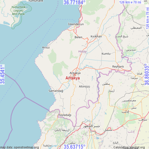
Antakya GPS coordinates[2]
36° 12' 23.58" North, 36° 9' 25.992" East
| Map corner | latitude | longitude |
|---|---|---|
| Upper-left | 36.77184°, | 35.4541° |
| Center: | 36.20655°, | 36.15722° |
| Lower-right: | 35.63715°, | 36.86035° |
| Map W x H: | 126.2×126.2 km | = 78.4×78.4mi |
| max Lat: | 42.02683° ⇑98.6% North |
| Antakya: | 36.20655° |
| min Lat: | ⇓1.4% South 35.9025° |
| min Long | Antakya | max Long |
| 25.90902° | 36.15722° | 44.60099° |
| W 51.7%⇐ | ⇒48.3% E |
Elevation
Elevation of Antakya is 104 m = 341 ft, and this is 613.4 m = 2012 ft below average elevation for this country.
| Max E: |
2682 m = 8799 ft | 81.2% |
| Avg. | 717.4 m = 2354 ft | |
| Antakya | 104 m = 341 ft | |
Min E: |
0 m = 0 ft | 18.8% |
See also: Antakya elevation on elevation.city.
Geographical zone
Antakya is located in North temperate zone (between Tropic of Cancer and the Arctic Circle). Distance of this Northern Tropic circle is 1419.9 km =882.3 mi to South.| Distance of | km | miles | from Antakya |
|---|---|---|---|
| North Pole | 5981.3 | 3716.6 | to North |
| Arctic Circle | 3375.4 | 2097.4 | to North |
| Tropic Cancer | 1419.9 | 882.3 | to South |
| Equator | 4025.8 | 2501.5 | to South |


Nearby cities:
15 places around Antakya: (largest is in red/bold)
• Aşağıokçular
3.5 km =2.2 mi,  205°
205°
• Doğanköy
5.2 km =3.2 mi,  304°
304°
• Dursunlu
4.4 km =2.7 mi,  179°
179°
• Gümüşgöze
6.9 km =4.3 mi,  198°
198°
• Güneysöğüt
5.5 km =3.4 mi,  227°
227°
• Günyazı
4.7 km =2.9 mi,  309°
309°
• Hancağız
8.8 km =5.5 mi, 228°
• Harbiye
8.1 km =5 mi, 195°
• Hıdırbey
2.6 km =1.6 mi,  273°
273°
• Kastal
8.8 km =5.5 mi,  58°
58°
• Kuzeytepe
6.5 km =4 mi,  357°
357°
• Mansurlu
6.8 km =4.2 mi,  76°
76°
• Samankaya
6.8 km =4.2 mi, 202°
• Tepehan
8.3 km =5.2 mi,  129°
129°
• Toygarlı
7.6 km =4.7 mi,  275°
275°
In other languages:
- In Spanish: Antioquía
- In France: Antioche
- In Italian: Antiochia di Siria
- In Russian: Антиохия
Sources, notices
• [Note1] Compared only with cities in Turkey existing in our database
• [Src1] Map data: © OpenStreetMap contributors (CC-BY-SA)
• [Src2] Other city data from geonames.org with taken over terms of usage.
• [Src3] Geographical zone / Annual Mean Temperature by Robert A. Rohde @ Wikipedia
