Beycuma geodata
Beycuma (Zonguldak) is a seat of a third-order administrative division; located in Turkey in Europe/Istanbul (GMT+3) time zone. In our database, there are 1323 cities with bigger population. Compared to other cities in Turkey, 95.8% of cities are located further ↓South; 66.7% of cities are located further →East and 74.3% of cities have higher elevation than Beycuma. Note1


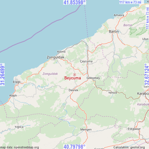
Beycuma GPS coordinates[2]
41° 19' 41.232" North, 31° 58' 5.196" East
| Map corner | latitude | longitude |
|---|---|---|
| Upper-left | 41.85398°, | 31.26499° |
| Center: | 41.32812°, | 31.96811° |
| Lower-right: | 40.79798°, | 32.67124° |
| Map W x H: | 117.4×117.4 km | = 72.9×72.9mi |
| max Lat: | 42.02683° ⇑4.2% North |
| Beycuma: | 41.32812° |
| min Lat: | ⇓95.8% South 35.9025° |
| min Long | Beycuma | max Long |
| 25.90902° | 31.96811° | 44.60099° |
| W 33.3%⇐ | ⇒66.7% E |
Elevation
Elevation of Beycuma is 185 m = 607 ft, and this is 532.4 m = 1747 ft below average elevation for this country.
| Max E: |
2682 m = 8799 ft | 74.3% |
| Avg. | 717.4 m = 2354 ft | |
| Beycuma | 185 m = 607 ft | |
Min E: |
0 m = 0 ft | 25.7% |
See also: Turkey elevation on elevation.city.
Geographical zone
Beycuma is located in North temperate zone (between Tropic of Cancer and the Arctic Circle). Distance of this Northern Tropic circle is 1989.3 km =1236.1 mi to South.| Distance of | km | miles | from Beycuma |
|---|---|---|---|
| North Pole | 5411.8 | 3362.7 | to North |
| Arctic Circle | 2805.9 | 1743.5 | to North |
| Tropic Cancer | 1989.3 | 1236.1 | to South |
| Equator | 4595.3 | 2855.4 | to South |


Nearby cities:
15 places around Beycuma: (largest is in red/bold)
• Devrek
12.2 km =7.6 mi,  184°
184°
• Eğerci
28.4 km =17.6 mi,  206°
206°
• Filyos
25.5 km =15.8 mi,  10°
10°
• Gökçebey
14.8 km =9.2 mi,  99°
99°
• Kilimli
21.1 km =13.1 mi,  329°
329°
• Kozcağız
35 km =21.7 mi,  60°
60°
• Kozlu
21.8 km =13.5 mi,  301°
301°
• Kumluca
43.7 km =27.2 mi,  72°
72°
• Mengen
44.2 km =27.5 mi,  168°
168°
• Ormanlı
34.7 km =21.6 mi,  238°
238°
• Perşembe
18.9 km =11.7 mi, 57°
• Saltukova
23.9 km =14.9 mi,  26°
26°
• Yenice
33.6 km =20.9 mi,  115°
115°
• Zonguldak
20 km =12.4 mi,  313°
313°
• Çaycuma
14.1 km =8.8 mi,  39°
39°
Sources, notices
• [Note1] Compared only with cities in Turkey existing in our database
• [Src1] Map data: © OpenStreetMap contributors (CC-BY-SA)
• [Src2] Other city data from geonames.org with taken over terms of usage.
• [Src3] Geographical zone / Annual Mean Temperature by Robert A. Rohde @ Wikipedia
