Eğerci geodata
Eğerci (Zonguldak) is a seat of a third-order administrative division; located in Turkey in Europe/Istanbul (GMT+3) time zone. In our database, there are 1323 cities with bigger population. Compared to other cities in Turkey, 92.3% of cities are located further ↓South; 67.5% of cities are located further →East and 71% of cities have higher elevation than Eğerci. Note1


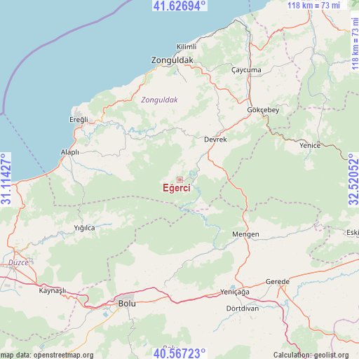
Eğerci GPS coordinates[2]
41° 5' 57.192" North, 31° 49' 2.604" East
| Map corner | latitude | longitude |
|---|---|---|
| Upper-left | 41.62694°, | 31.11427° |
| Center: | 41.09922°, | 31.81739° |
| Lower-right: | 40.56723°, | 32.52052° |
| Map W x H: | 117.8×117.8 km | = 73.2×73.2mi |
| max Lat: | 42.02683° ⇑7.7% North |
| Eğerci: | 41.09922° |
| min Lat: | ⇓92.3% South 35.9025° |
| min Long | Eğerci | max Long |
| 25.90902° | 31.81739° | 44.60099° |
| W 32.5%⇐ | ⇒67.5% E |
Elevation
Elevation of Eğerci is 262 m = 860 ft, and this is 455.4 m = 1494 ft below average elevation for this country.
| Max E: |
2682 m = 8799 ft | 71% |
| Avg. | 717.4 m = 2354 ft | |
| Eğerci | 262 m = 860 ft | |
Min E: |
0 m = 0 ft | 29% |
See also: Turkey elevation on elevation.city.
Geographical zone
Eğerci is located in North temperate zone (between Tropic of Cancer and the Arctic Circle). Distance of this Northern Tropic circle is 1963.9 km =1220.3 mi to South.| Distance of | km | miles | from Eğerci |
|---|---|---|---|
| North Pole | 5437.3 | 3378.6 | to North |
| Arctic Circle | 2831.4 | 1759.3 | to North |
| Tropic Cancer | 1963.9 | 1220.3 | to South |
| Equator | 4569.8 | 2839.5 | to South |


Nearby cities:
15 places around Eğerci: (largest is in red/bold)
• Alaplı
37.3 km =23.2 mi,  284°
284°
• Beycuma
28.4 km =17.6 mi,  26°
26°
• Devrek
17.7 km =11 mi,  40°
40°
• Ereğli
39.1 km =24.3 mi,  301°
301°
• Gökçebey
35.6 km =22.1 mi,  49°
49°
• Gökçesu
25.8 km =16 mi,  152°
152°
• Kilimli
43.6 km =27.1 mi,  2°
2°
• Kozlu
37.5 km =23.3 mi,  350°
350°
• Mengen
28.1 km =17.5 mi,  129°
129°
• Ormanlı
18.5 km =11.5 mi,  293°
293°
• Pazarköy
36.1 km =22.4 mi,  122°
122°
• Yeniçağa
40.8 km =25.4 mi, 153°
• Yığılca
35 km =21.7 mi,  243°
243°
• Zonguldak
39.2 km =24.4 mi,  357°
357°
• Çaycuma
42.3 km =26.3 mi, 30°
Sources, notices
• [Note1] Compared only with cities in Turkey existing in our database
• [Src1] Map data: © OpenStreetMap contributors (CC-BY-SA)
• [Src2] Other city data from geonames.org with taken over terms of usage.
• [Src3] Geographical zone / Annual Mean Temperature by Robert A. Rohde @ Wikipedia
