Yenice geodata
Yenice (Karabük) is a seat of a second-order administrative division; located in Turkey in Europe/Istanbul (GMT+3) time zone. In our database, there are 1323 cities with bigger population. Compared to other cities in Turkey, 94.1% of cities are located further ↓South; 65.3% of cities are located further →East and 78% of cities have higher elevation than Yenice. Note1


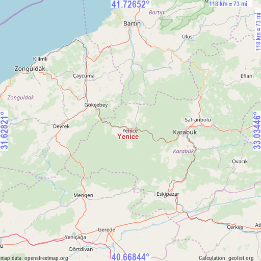
Yenice GPS coordinates[2]
41° 11' 58.632" North, 32° 19' 52.788" East
| Map corner | latitude | longitude |
|---|---|---|
| Upper-left | 41.72652°, | 31.62821° |
| Center: | 41.19962°, | 32.33133° |
| Lower-right: | 40.66844°, | 33.03446° |
| Map W x H: | 117.6×117.6 km | = 73.1×73.1mi |
| max Lat: | 42.02683° ⇑5.9% North |
| Yenice: | 41.19962° |
| min Lat: | ⇓94.1% South 35.9025° |
| min Long | Yenice | max Long |
| 25.90902° | 32.33133° | 44.60099° |
| W 34.7%⇐ | ⇒65.3% E |
Elevation
Elevation of Yenice is 137 m = 449 ft, and this is 580.4 m = 1904 ft below average elevation for this country.
| Max E: |
2682 m = 8799 ft | 78% |
| Avg. | 717.4 m = 2354 ft | |
| Yenice | 137 m = 449 ft | |
Min E: |
0 m = 0 ft | 22% |
See also: Turkey elevation on elevation.city.
Geographical zone
Yenice is located in North temperate zone (between Tropic of Cancer and the Arctic Circle). Distance of this Northern Tropic circle is 1975 km =1227.2 mi to South.| Distance of | km | miles | from Yenice |
|---|---|---|---|
| North Pole | 5426.1 | 3371.6 | to North |
| Arctic Circle | 2820.2 | 1752.4 | to North |
| Tropic Cancer | 1975 | 1227.2 | to South |
| Equator | 4581 | 2846.5 | to South |


Nearby cities:
15 places around Yenice: (largest is in red/bold)
• Beycuma
33.6 km =20.9 mi,  295°
295°
• Devrek
31.5 km =19.6 mi,  273°
273°
• Eskipazar
33.1 km =20.6 mi,  149°
149°
• Eğerci
44.5 km =27.7 mi,  255°
255°
• Gökçebey
19.7 km =12.2 mi,  306°
306°
• Gözyeri
41.1 km =25.5 mi, 154°
• Karabük
24.8 km =15.4 mi,  88°
88°
• Kozcağız
31.5 km =19.6 mi,  0°
0°
• Kumluca
29.8 km =18.5 mi,  22°
22°
• Mengen
36 km =22.4 mi,  216°
216°
• Pazarköy
33 km =20.5 mi,  202°
202°
• Perşembe
28.3 km =17.6 mi,  329°
329°
• Safranbolu
30.9 km =19.2 mi,  79°
79°
• Saltukova
40.7 km =25.3 mi, 331°
• Çaycuma
33 km =20.5 mi,  319°
319°
Sources, notices
• [Note1] Compared only with cities in Turkey existing in our database
• [Src1] Map data: © OpenStreetMap contributors (CC-BY-SA)
• [Src2] Other city data from geonames.org with taken over terms of usage.
• [Src3] Geographical zone / Annual Mean Temperature by Robert A. Rohde @ Wikipedia
