Filyos geodata
Filyos (Zonguldak) is a seat of a third-order administrative division; located in Turkey in Europe/Istanbul (GMT+3) time zone. In our database, there are 1323 cities with bigger population. Compared to other cities in Turkey, 97.8% of cities are located further ↓South; 66.5% of cities are located further →East and 91.5% of cities have higher elevation than Filyos. Note1


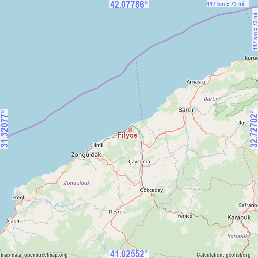
Filyos GPS coordinates[2]
41° 33' 13.788" North, 32° 1' 26.004" East
| Map corner | latitude | longitude |
|---|---|---|
| Upper-left | 42.07786°, | 31.32077° |
| Center: | 41.55383°, | 32.02389° |
| Lower-right: | 41.02552°, | 32.72702° |
| Map W x H: | 117×117 km | = 72.7×72.7mi |
| max Lat: | 42.02683° ⇑2.2% North |
| Filyos: | 41.55383° |
| min Lat: | ⇓97.8% South 35.9025° |
| min Long | Filyos | max Long |
| 25.90902° | 32.02389° | 44.60099° |
| W 33.5%⇐ | ⇒66.5% E |
Elevation
Elevation of Filyos is 31 m = 102 ft, and this is 686.4 m = 2252 ft below average elevation for this country.
| Max E: |
2682 m = 8799 ft | 91.5% |
| Avg. | 717.4 m = 2354 ft | |
| Filyos | 31 m = 102 ft | |
Min E: |
0 m = 0 ft | 8.5% |
See also: Turkey elevation on elevation.city.
Geographical zone
Filyos is located in North temperate zone (between Tropic of Cancer and the Arctic Circle). Distance of this Northern Tropic circle is 2014.4 km =1251.7 mi to South.| Distance of | km | miles | from Filyos |
|---|---|---|---|
| North Pole | 5386.7 | 3347.1 | to North |
| Arctic Circle | 2780.8 | 1727.9 | to North |
| Tropic Cancer | 2014.4 | 1251.7 | to South |
| Equator | 4620.4 | 2871 | to South |


Nearby cities:
15 places around Filyos: (largest is in red/bold)
• Amasra
36.9 km =22.9 mi,  54°
54°
• Bartın
27.6 km =17.1 mi,  70°
70°
• Beycuma
25.5 km =15.8 mi,  190°
190°
• Devrek
37.6 km =23.4 mi, 188°
• Gökçebey
29.3 km =18.2 mi,  160°
160°
• Kilimli
16.9 km =10.5 mi,  245°
245°
• Kozcağız
26.9 km =16.7 mi,  106°
106°
• Kozlu
26.8 km =16.7 mi,  239°
239°
• Kumluca
38.8 km =24.1 mi, 107°
• Perşembe
18.8 km =11.7 mi,  143°
143°
• Saltukova
7.1 km =4.4 mi,  121°
121°
• Ulus
51.5 km =32 mi,  86°
86°
• Yenice
47 km =29.2 mi,  146°
146°
• Zonguldak
22.3 km =13.9 mi, 239°
• Çaycuma
14.8 km =9.2 mi, 163°
Sources, notices
• [Note1] Compared only with cities in Turkey existing in our database
• [Src1] Map data: © OpenStreetMap contributors (CC-BY-SA)
• [Src2] Other city data from geonames.org with taken over terms of usage.
• [Src3] Geographical zone / Annual Mean Temperature by Robert A. Rohde @ Wikipedia
