İnebolu geodata
İnebolu (Kastamonu) is a seat of a second-order administrative division; located in Turkey in Europe/Istanbul (GMT+3) time zone. With population of 9,935 people, there are 514 cities with bigger population in this country. Compared to other cities in Turkey, 99.9% of cities are located further ↓South; 59.3% of cities are located further →East and 95% of cities have higher elevation than İnebolu. Note1


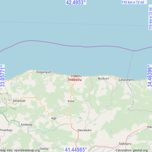
İnebolu GPS coordinates[2]
41° 58' 28.992" North, 33° 45' 38.988" East
| Map corner | latitude | longitude |
|---|---|---|
| Upper-left | 42.4953°, | 33.05771° |
| Center: | 41.97472°, | 33.76083° |
| Lower-right: | 41.44985°, | 34.46396° |
| Map W x H: | 116.2×116.2 km | = 72.2×72.2mi |
| max Lat: | 42.02683° ⇑0.1% North |
| İnebolu: | 41.97472° |
| min Lat: | ⇓99.9% South 35.9025° |
| min Long | İnebolu | max Long |
| 25.90902° | 33.76083° | 44.60099° |
| W 40.7%⇐ | ⇒59.3% E |
Elevation
Elevation of İnebolu is 16 m = 52 ft, and this is 701.4 m = 2301 ft below average elevation for this country.
| Max E: |
2682 m = 8799 ft | 95% |
| Avg. | 717.4 m = 2354 ft | |
| İnebolu | 16 m = 52 ft | |
Min E: |
0 m = 0 ft | 5% |
See also: Turkey elevation on elevation.city.
Geographical zone
İnebolu is located in North temperate zone (between Tropic of Cancer and the Arctic Circle). Distance of this Northern Tropic circle is 2061.2 km =1280.8 mi to South.| Distance of | km | miles | from İnebolu |
|---|---|---|---|
| North Pole | 5339.9 | 3318.1 | to North |
| Arctic Circle | 2734 | 1698.8 | to North |
| Tropic Cancer | 2061.2 | 1280.8 | to South |
| Equator | 4667.2 | 2900.1 | to South |


Nearby cities:
15 places around İnebolu: (largest is in red/bold)
• Abana
20.7 km =12.9 mi,  88°
88°
• Azdavay
53.1 km =33 mi,  225°
225°
• Ağlı
36.4 km =22.6 mi,  208°
208°
• Bozkurt
20.8 km =12.9 mi,  95°
95°
• Cide
63.2 km =39.3 mi,  261°
261°
• Daday
60.3 km =37.5 mi,  203°
203°
• Devrekani
41.8 km =26 mi,  171°
171°
• Doğanyurt
25.1 km =15.6 mi,  277°
277°
• Güzelkent
52.5 km =32.6 mi, 93°
• Küre
19.2 km =11.9 mi,  192°
192°
• Seydiler
39.6 km =24.6 mi, 185°
• Taşköprü
63.9 km =39.7 mi,  143°
143°
• Türkeli
47.9 km =29.8 mi, 93°
• Çatalzeytin
37.7 km =23.4 mi, 93°
• Şenpazar
47.5 km =29.5 mi,  247°
247°
Sources, notices
• [Note1] Compared only with cities in Turkey existing in our database
• [Src1] Map data: © OpenStreetMap contributors (CC-BY-SA)
• [Src2] Other city data from geonames.org with taken over terms of usage.
• [Src3] Geographical zone / Annual Mean Temperature by Robert A. Rohde @ Wikipedia
