Ağlı geodata
Ağlı (Kastamonu) is a seat of a second-order administrative division; located in Turkey in Europe/Istanbul (GMT+3) time zone. In our database, there are 1323 cities with bigger population. Compared to other cities in Turkey, 98.6% of cities are located further ↓South; 60% of cities are located further →East and 79.4% of cities have lower elevation than Ağlı. Note1


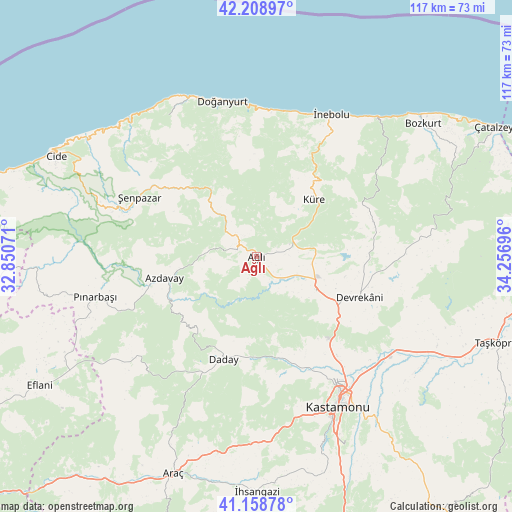
Ağlı GPS coordinates[2]
41° 41' 9.672" North, 33° 33' 13.788" East
| Map corner | latitude | longitude |
|---|---|---|
| Upper-left | 42.20897°, | 32.85071° |
| Center: | 41.68602°, | 33.55383° |
| Lower-right: | 41.15878°, | 34.25696° |
| Map W x H: | 116.8×116.8 km | = 72.6×72.6mi |
| max Lat: | 42.02683° ⇑1.4% North |
| Ağlı: | 41.68602° |
| min Lat: | ⇓98.6% South 35.9025° |
| min Long | Ağlı | max Long |
| 25.90902° | 33.55383° | 44.60099° |
| W 40%⇐ | ⇒60% E |
Elevation
Elevation of Ağlı is 1181 m = 3875 ft, and this is 463.6 m = 1521 ft above average elevation for this country.
| Max E: |
2682 m = 8799 ft | 20.6% |
| Ağlı | 1181 m 3875 ft | |
| Avg. | 717.4 m = 2354 ft | |
Min E: |
0 m = 0 ft | 79.4% |
See also: Turkey elevation on elevation.city.
Geographical zone
Ağlı is located in North temperate zone (between Tropic of Cancer and the Arctic Circle). Distance of this Northern Tropic circle is 2029.1 km =1260.8 mi to South.| Distance of | km | miles | from Ağlı |
|---|---|---|---|
| North Pole | 5372 | 3338 | to North |
| Arctic Circle | 2766.1 | 1718.8 | to North |
| Tropic Cancer | 2029.1 | 1260.8 | to South |
| Equator | 4635.1 | 2880.1 | to South |


Nearby cities:
15 places around Ağlı: (largest is in red/bold)
• Abana
49.9 km =31 mi,  49°
49°
• Akkaya
52.2 km =32.4 mi,  186°
186°
• Azdavay
21.6 km =13.4 mi,  257°
257°
• Bozkurt
48.4 km =30.1 mi, 51°
• Cide
51 km =31.7 mi,  296°
296°
• Daday
24.2 km =15 mi,  197°
197°
• Devrekani
25.4 km =15.8 mi,  111°
111°
• Doğanyurt
36.3 km =22.6 mi,  347°
347°
• Kastamonu
38.9 km =24.2 mi,  151°
151°
• Kuzyaka
52.4 km =32.6 mi,  164°
164°
• Küre
18.7 km =11.6 mi,  44°
44°
• Pınarbaşı
37.9 km =23.5 mi, 256°
• Seydiler
15.5 km =9.6 mi,  118°
118°
• İnebolu
36.4 km =22.6 mi,  28°
28°
• Şenpazar
30 km =18.6 mi, 297°
Sources, notices
• [Note1] Compared only with cities in Turkey existing in our database
• [Src1] Map data: © OpenStreetMap contributors (CC-BY-SA)
• [Src2] Other city data from geonames.org with taken over terms of usage.
• [Src3] Geographical zone / Annual Mean Temperature by Robert A. Rohde @ Wikipedia
