Hasayaz geodata
Hasayaz (Ankara) is a seat of a third-order administrative division; located in Turkey in Europe/Istanbul (GMT+3) time zone. In our database, there are 1323 cities with bigger population. Compared to other cities in Turkey, 73.4% of cities are located further ↓South; 61% of cities are located further →East and 68.1% of cities have lower elevation than Hasayaz. Note1


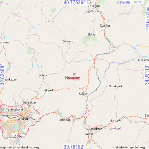
Hasayaz GPS coordinates[2]
40° 14' 26.412" North, 33° 19' 40.8" East
| Map corner | latitude | longitude |
|---|---|---|
| Upper-left | 40.77526°, | 32.62488° |
| Center: | 40.24067°, | 33.328° |
| Lower-right: | 39.70182°, | 34.03113° |
| Map W x H: | 119.4×119.4 km | = 74.2×74.2mi |
| max Lat: | 42.02683° ⇑26.6% North |
| Hasayaz: | 40.24067° |
| min Lat: | ⇓73.4% South 35.9025° |
| min Long | Hasayaz | max Long |
| 25.90902° | 33.328° | 44.60099° |
| W 39%⇐ | ⇒61% E |
Elevation
Elevation of Hasayaz is 1000 m = 3281 ft, and this is 282.6 m = 927 ft above average elevation for this country.
| Max E: |
2682 m = 8799 ft | 31.9% |
| Hasayaz | 1000 m 3281 ft | |
| Avg. | 717.4 m = 2354 ft | |
Min E: |
0 m = 0 ft | 68.1% |
See also: Turkey elevation on elevation.city.
Geographical zone
Hasayaz is located in North temperate zone (between Tropic of Cancer and the Arctic Circle). Distance of this Northern Tropic circle is 1868.4 km =1161 mi to South.| Distance of | km | miles | from Hasayaz |
|---|---|---|---|
| North Pole | 5532.7 | 3437.9 | to North |
| Arctic Circle | 2926.8 | 1818.6 | to North |
| Tropic Cancer | 1868.4 | 1161 | to South |
| Equator | 4474.3 | 2780.2 | to South |


Nearby cities:
15 places around Hasayaz: (largest is in red/bold)
• Akyurt
23.7 km =14.7 mi,  240°
240°
• Balışeyh
49.5 km =30.8 mi,  137°
137°
• Eldivan
35.3 km =21.9 mi,  24°
24°
• Elmadağ
36.5 km =22.7 mi,  193°
193°
• Kalecik
17.3 km =10.7 mi,  156°
156°
• Khanjarah
46.8 km =29.1 mi,  31°
31°
• Kırıkkale
46.5 km =28.9 mi, 160°
• Mamak
48.8 km =30.3 mi,  226°
226°
• Orta
46.5 km =28.9 mi,  336°
336°
• Pursaklar
43.5 km =27 mi, 237°
• Sulakyurt
34.2 km =21.3 mi,  105°
105°
• Yahşihan
44.7 km =27.8 mi,  166°
166°
• Çandır
12.1 km =7.5 mi,  81°
81°
• Çubuk
25.1 km =15.6 mi,  269°
269°
• Şabanözü
27.2 km =16.9 mi,  352°
352°
Sources, notices
• [Note1] Compared only with cities in Turkey existing in our database
• [Src1] Map data: © OpenStreetMap contributors (CC-BY-SA)
• [Src2] Other city data from geonames.org with taken over terms of usage.
• [Src3] Geographical zone / Annual Mean Temperature by Robert A. Rohde @ Wikipedia
