Sulakyurt geodata
Sulakyurt (Kırıkkale) is a seat of a second-order administrative division; located in Turkey in Europe/Istanbul (GMT+3) time zone. With population of 6,592 people, there are 629 cities with bigger population in this country. Compared to other cities in Turkey, 71.7% of cities are located further ↓South; 59.6% of cities are located further →East and 57.4% of cities have lower elevation than Sulakyurt. Note1


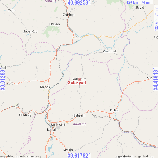
Sulakyurt GPS coordinates[2]
40° 9' 26.388" North, 33° 42' 57.6" East
| Map corner | latitude | longitude |
|---|---|---|
| Upper-left | 40.69258°, | 33.01288° |
| Center: | 40.15733°, | 33.716° |
| Lower-right: | 39.61782°, | 34.41913° |
| Map W x H: | 119.5×119.5 km | = 74.3×74.3mi |
| max Lat: | 42.02683° ⇑28.3% North |
| Sulakyurt: | 40.15733° |
| min Lat: | ⇓71.7% South 35.9025° |
| min Long | Sulakyurt | max Long |
| 25.90902° | 33.716° | 44.60099° |
| W 40.4%⇐ | ⇒59.6% E |
Elevation
Elevation of Sulakyurt is 833 m = 2733 ft, and this is 115.6 m = 379 ft above average elevation for this country.
| Max E: |
2682 m = 8799 ft | 42.6% |
| Sulakyurt | 833 m 2733 ft | |
| Avg. | 717.4 m = 2354 ft | |
Min E: |
0 m = 0 ft | 57.4% |
See also: Turkey elevation on elevation.city.
Geographical zone
Sulakyurt is located in North temperate zone (between Tropic of Cancer and the Arctic Circle). Distance of this Northern Tropic circle is 1859.2 km =1155.3 mi to South.| Distance of | km | miles | from Sulakyurt |
|---|---|---|---|
| North Pole | 5542 | 3443.6 | to North |
| Arctic Circle | 2936.1 | 1824.4 | to North |
| Tropic Cancer | 1859.2 | 1155.3 | to South |
| Equator | 4465.1 | 2774.5 | to South |


Nearby cities:
15 places around Sulakyurt: (largest is in red/bold)
• Akyurt
53.6 km =33.3 mi,  267°
267°
• Bahşılı
46.3 km =28.8 mi,  210°
210°
• Balışeyh
27.1 km =16.8 mi,  178°
178°
• Delice
34.8 km =21.6 mi,  130°
130°
• Eldivan
45.3 km =28.1 mi,  336°
336°
• Elmadağ
49 km =30.4 mi,  237°
237°
• Hasayaz
34.2 km =21.3 mi,  285°
285°
• Kalecik
27 km =16.8 mi,  255°
255°
• Khanjarah
49.9 km =31 mi,  350°
350°
• Kırıkkale
39 km =24.2 mi, 207°
• Kızılırmak
31.1 km =19.3 mi,  47°
47°
• Salmanlı
53.9 km =33.5 mi,  121°
121°
• Yahşihan
40.8 km =25.4 mi, 213°
• Çandır
23.8 km =14.8 mi,  297°
297°
• Şabanözü
51.5 km =32 mi,  314°
314°
Sources, notices
• [Note1] Compared only with cities in Turkey existing in our database
• [Src1] Map data: © OpenStreetMap contributors (CC-BY-SA)
• [Src2] Other city data from geonames.org with taken over terms of usage.
• [Src3] Geographical zone / Annual Mean Temperature by Robert A. Rohde @ Wikipedia
