Balışeyh geodata
Balışeyh (Kırıkkale) is a seat of a second-order administrative division; located in Turkey in Europe/Istanbul (GMT+3) time zone. With population of 4,150 people, there are 768 cities with bigger population in this country. Compared to other cities in Turkey, 67.7% of cities are located further ↓South; 59.4% of cities are located further →East and 59.8% of cities have lower elevation than Balışeyh. Note1


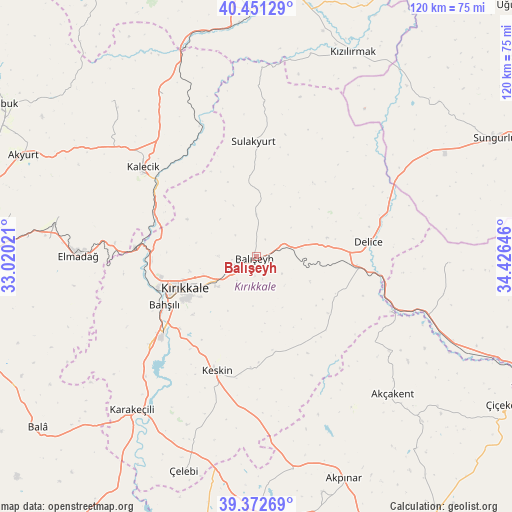
Balışeyh GPS coordinates[2]
39° 54' 50.796" North, 33° 43' 23.988" East
| Map corner | latitude | longitude |
|---|---|---|
| Upper-left | 40.45129°, | 33.02021° |
| Center: | 39.91411°, | 33.72333° |
| Lower-right: | 39.37269°, | 34.42646° |
| Map W x H: | 119.9×119.9 km | = 74.5×74.5mi |
| max Lat: | 42.02683° ⇑32.3% North |
| Balışeyh: | 39.91411° |
| min Lat: | ⇓67.7% South 35.9025° |
| min Long | Balışeyh | max Long |
| 25.90902° | 33.72333° | 44.60099° |
| W 40.6%⇐ | ⇒59.4% E |
Elevation
Elevation of Balışeyh is 878 m = 2881 ft, and this is 160.6 m = 527 ft above average elevation for this country.
| Max E: |
2682 m = 8799 ft | 40.2% |
| Balışeyh | 878 m 2881 ft | |
| Avg. | 717.4 m = 2354 ft | |
Min E: |
0 m = 0 ft | 59.8% |
See also: Turkey elevation on elevation.city.
Geographical zone
Balışeyh is located in North temperate zone (between Tropic of Cancer and the Arctic Circle). Distance of this Northern Tropic circle is 1832.1 km =1138.4 mi to South.| Distance of | km | miles | from Balışeyh |
|---|---|---|---|
| North Pole | 5569 | 3460.4 | to North |
| Arctic Circle | 2963.1 | 1841.2 | to North |
| Tropic Cancer | 1832.1 | 1138.4 | to South |
| Equator | 4438 | 2757.6 | to South |


Nearby cities:
15 places around Balışeyh: (largest is in red/bold)
• Akçakent
45.4 km =28.2 mi,  135°
135°
• Bahşılı
27.5 km =17.1 mi,  242°
242°
• Delice
26.2 km =16.3 mi,  80°
80°
• Elmadağ
42 km =26.1 mi,  271°
271°
• Hasayaz
49.5 km =30.8 mi,  317°
317°
• Kalecik
33.7 km =20.9 mi,  307°
307°
• Karakeçili
46.2 km =28.7 mi,  219°
219°
• Keskin
28.4 km =17.6 mi,  199°
199°
• Kösefakılı
50.1 km =31.1 mi, 135°
• Kırıkkale
20 km =12.4 mi,  247°
247°
• Kızılırmak
52.9 km =32.9 mi,  24°
24°
• Salmanlı
45.3 km =28.1 mi,  91°
91°
• Sulakyurt
27.1 km =16.8 mi,  358°
358°
• Yahşihan
24.1 km =15 mi, 252°
• Çandır
43.9 km =27.3 mi,  330°
330°
Sources, notices
• [Note1] Compared only with cities in Turkey existing in our database
• [Src1] Map data: © OpenStreetMap contributors (CC-BY-SA)
• [Src2] Other city data from geonames.org with taken over terms of usage.
• [Src3] Geographical zone / Annual Mean Temperature by Robert A. Rohde @ Wikipedia
